East Jaffrey Historic District
|
East Jaffrey Historic District | |
|
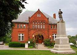
The Jaffrey Library | |
  | |
| Location | Roughly along NH 124 through Jaffrey, Jaffrey, New Hampshire |
|---|---|
| Coordinates | 42°48′56″N 72°1′30″W / 42.81556°N 72.02500°WCoordinates: 42°48′56″N 72°1′30″W / 42.81556°N 72.02500°W |
| Area | 75 acres (30 ha) |
| NRHP Reference # | [1] |
| Added to NRHP | June 14, 2002 |
The East Jaffrey Historic District is a historic district running roughly along NH Route 124 (Main Street) through Jaffrey, New Hampshire. It encompasses what is now the economic and civic heart of the town, centered on the Jaffrey Mills and the crossing of the Contoocook River by Route 124. It extends as far west as St. Patrick's Church beyond Charlonne Street and as far east as the US Post Office building at Route 124 and Ellison Street. To the north it extends along Peterborough Street (United States Route 202) to Christian Court, and to the south it extends along River Street (also US 202) and School Street to their junction. The district includes early 19th-century residential structures, as well as industrial buildings and housing associated with the Jaffrey Mills which arose in the mid-19th century. The area was known as "East Jaffrey" prior to its rise in economic ascendancy over what is now Jaffrey Center, the center of Jaffrey when it was chartered in 1773.[2]
The district was added to the National Register of Historic Places in 2002.[1]
See also
References
- 1 2 National Park Service (2009-03-13). "National Register Information System". National Register of Historic Places. National Park Service.
- ↑ "NRHP nomination for East Jaffrey Historic District" (PDF). National Park Service. Retrieved 2014-10-29.
| Topics |  | |
|---|---|---|
| Lists by county | ||
| Other lists | ||
| ||
