East Taphouse
Coordinates: 50°26′28″N 4°33′54″W / 50.441°N 4.565°W
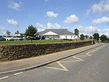
Braddock Primary School, East Taphouse
East Taphouse (Cornish: Diwotti Est) is a village in Cornwall, England, United Kingdom. It is situated in the civil parish of St Pinnock, one mile west of Doublebois on the A390 Liskeard to St Austell road.[1] A little further west are the hamlets of Middle Taphouse and West Taphouse.
References
- ↑ Ordnance Survey: Landranger map sheet 201 Plymouth & Launceston ISBN 978-0-319-23146-3
External links
![]() Media related to East Taphouse at Wikimedia Commons
Media related to East Taphouse at Wikimedia Commons
Cornwall Portal | |
| Unitary authorities | |
| Major settlements |
|
| Rivers | |
| Topics | |
This article is issued from Wikipedia - version of the 1/23/2016. The text is available under the Creative Commons Attribution/Share Alike but additional terms may apply for the media files.
