El Dorado Hills, California
| El Dorado Hills | |
|---|---|
| Census designated place | |
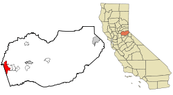
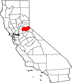
 Location in El Dorado County and the state of California | |
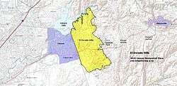
 Map of El Dorado Hills and surrounding region | |
 El Dorado Hills Location in the United States | |
| Coordinates: 38°41′09″N 121°04′56″W / 38.68583°N 121.08222°WCoordinates: 38°41′09″N 121°04′56″W / 38.68583°N 121.08222°W | |
| Country |
|
| State |
|
| County | El Dorado |
| Area[1] | |
| • Total | 48.606 sq mi (125.888 km2) |
| • Land | 48.454 sq mi (125.494 km2) |
| • Water | 0.152 sq mi (0.394 km2) 0.31% |
| Elevation[2] | 768 ft (234 m) |
| Population (April 1, 2010) | |
| • Total | 42,108 |
| • Density | 870/sq mi (330/km2) |
| Time zone | Pacific (UTC-8) |
| • Summer (DST) | PDT (UTC-7) |
| ZIP code | 95762 |
| Area codes | 916, 530 |
| FIPS code | 06-21880 |
| GNIS feature IDs | 1867020, 2408055 |
El Dorado Hills (EDH) is an unincorporated census-designated place (CDP) located in El Dorado County, California, 22 miles (35 km) east of the state capital of Sacramento. The population was 42,108 at the 2010 census, up from 18,016 at the 2000 census.[3] This population growth is attributed through the combination of actual population increase within the 2000 CDP boundaries and expansion of the boundaries. The area of EDH was expanded from 17.9 square miles (46 km2) in 2000 to 48.606 square miles (125.89 km2) in 2010.[3]
El Dorado Hills residents and businesses are most closely affiliated with El Dorado County, a generally rural area. However, El Dorado County is part of the Sacramento Metropolitan Area because it is socially and economically integrated with the much larger Sacramento County and especially the City of Folsom.[4][5] El Dorado Hills is recognized nationally for its high median household income, ranking 77th in CNN Money Magazine's best places to live in 2007,[6] with the median household income for 2007 over $115,000.[7]
History
El Dorado Hills lies about 18.6 miles from the 1848 gold find site in Coloma, the impetus for the California Gold Rush. Gold was washed down the South Fork of the American River, into areas now in El Dorado Hills and Folsom, but farming and ranching supplanted the Gold Rush. Portions of two Pony Express routes in this area from 1860-1861 remain as modern El Dorado Hills roads. El Dorado Hills includes the longest surviving section of the Lincoln Highway, the first U.S. transcontinental highway. This section, part of the Pioneer Branch, passes through historic Clarksville and is the predecessor of the modern US 50 route. (?) tely planned from its inception as a group of residential "villages". Other land uses in the master plan included a business park, 18-hole golf course, community parks, schools, a community shopping center, and small commercial centers in each village. The master plan emphasized open space between villages and opportunity for outdoor recreation.
Between the late '60s and mid-1990s growth occurred at a moderate pace as new families relocated from Sacramento, Southern California and the Bay Area. This growth consisted primarily of residential housing, as retail developments were limited to two shopping centers on the corners Green Valley & Francisco and El Dorado Hills Blvd. & Hwy. 50. Each neighborhood created during this time period was given a name and referred to as a "village" by local inhabitants. The original villages of El Dorado Hills include Park, Saint Andrews, Crown, Governors. In the 1980s and 1990s the major part of Lake Hills Estates north of Green Valley Road, was reorganized into Lake Forest Village,[8] containing the neighborhoods of Waterford, The Summit,[9] Green Valley Hills, Winterhaven, Marina Woods and Windsor Point. Additional villages that have developed subsequently include Fairchild, Sterlingshire, Highland Hills, Highland View, Bridlewood, Hills of El Dorado, Woodridge, Laural Oaks and the master-planned community of Serrano.
The 1990 census, reported that El Dorado Hills had a population of 6,395.[10] Growth slowed during the early part of the '90s due to economic recession throughout California, but resumed at a staggering pace by the mid-1990s. Businesses, particularly those interested in escaping the high costs of Silicon Valley began to set up operations in the El Dorado Hills Business Park south of Highway 50.[11] In 1995, the Parker Development Company acquired 3,500 acres (14 km2) along the eastern boundary of El Dorado Hills to create Serrano, one of the largest master planned communities in Northern California. Serrano was the site of an innovative case of recycled water irrigation on a large scale.[12]
Around 2000, its population growth and commercial development greatly accelerated. Development began in its Town Center Zone to form a true downtown business area, and its Business Park experienced increasing rates of construction and occupancy.
The new El Dorado Hills Town Center is located just south of Hwy 50. The all-new mixed-use project, a development of The Mansour Company, has successfully pulled together a great mix of uses – local and national retailers, cafés, restaurants and bars, movie theater, hotel, gourmet market, fitness club, day spa, luxury car dealership, professional and medical offices, public amphitheatre, dramatic fountains and waterways, and broad public plazas. Occupying 100 acres of land and, at completion, one million square feet of buildings, it is the center of town and of the region – a place where the community can gather to shop, dine, work, go to the movies, enjoy a concert, and relax on public plazas.[13]
Many families continue to relocate to El Dorado Hills from Sacramento, Southern California and primarily the Bay Area. The housing prices for El Dorado Hills typically range from the low $300,000's to $4 million range. There are exclusive neighborhoods that offer high end luxury homes such as Serrano Golf and Country Club, The Summit, Watermark, Marina Hills and Highland Hills.[14]
Geography and environment
El Dorado Hills (EDH), as defined by the 2010 census-designated place (CDP), is at the western border of El Dorado County, between the City of Folsom and the unincorporated community of Cameron Park. The northern limits of the CDP are Folsom and the South Fork of the American River, where river rafters use Skunk Hollow and Salmon Falls as takeout landings. West of Latrobe Road, the south edge of the CDP follows railroad tracks formerly used by the Southern Pacific between the cities of Folsom and Placerville. East of Latrobe Road the south edge follows topography running roughly east/west.
The 2010 CDP has a land area of 48.606 square miles (125.89 km2), more than double the size of its boundaries in 2000 CDP, which was 17.9 square miles (46 km2).
US 50 is the major east-west highway running through El Dorado Hills. The portion of EDH north of US 50 is mainly residential. The portion south of US 50 includes the 885-acre El Dorado Hills Business Park and the Town Center Commercial area, as well as additional housing.
The subsurface environment of El Dorado Hills is relatively free of groundwater and soil contamination, based upon an areawide analysis of the potential for pesticide contamination and evaluation of underground storage tanks.(Earth Metrics, 1989)
Demographics
2010
The 2010 United States Census[3] reported that El Dorado Hills had a population of 42,108. The population density was 866.3 people per square mile (334.5/km²). The racial makeup of El Dorado Hills was 35,089 (83.3%) White, 615 (1.5%) African American, 196 (0.5%) Native American, 3,563 (8.5%) Asian, 71 (0.2%) Pacific Islander, 681 (1.6%) from other races, and 1,893 (4.5%) from two or more races. Hispanic or Latino of any race were 3,802 persons (9.0%).
The Census reported that 42,092 people (100% of the population) lived in households, 16 (0%) lived in non-institutionalized group quarters, and 0 (0%) were institutionalized.
There were 14,368 households, out of which 6,516 (45.4%) had children under the age of 18 living in them, 10,503 (73.1%) were opposite-sex married couples living together, 1,070 (7.4%) had a female householder with no husband present, 490 (3.4%) had a male householder with no wife present. There were 464 (3.2%) unmarried opposite-sex partnerships, and 85 (0.6%) same-sex married couples or partnerships. 1,798 households (12.5%) were made up of individuals and 670 (4.7%) had someone living alone who was 65 years of age or older. The average household size was 2.93. There were 12,063 families (84.0% of all households); the average family size was 3.20.
The population was spread out with 12,430 people (29.5%) under the age of 18, 2,511 people (6.0%) aged 18 to 24, 9,455 people (22.5%) aged 25 to 44, 13,232 people (31.4%) aged 45 to 64, and 4,480 people (10.6%) who were 65 years of age or older. The median age was 40.6 years. For every 100 females there were 97.5 males. For every 100 females age 18 and over, there were 94.7 males.
There were 14,994 housing units at an average density of 308.5 per square mile (119.1/km²), of which 12,169 (84.7%) were owner-occupied, and 2,199 (15.3%) were occupied by renters. The homeowner vacancy rate was 1.7%; the rental vacancy rate was 4.1%. 35,755 people (84.9% of the population) lived in owner-occupied housing units and 6,337 people (15.0%) lived in rental housing units.
2000
As of the census[15] of 2000, there were 18,016 people, 5,896 households, and 5,206 families residing in the CDP. The population density was 1,006.3 people per square mile (388.6/km²). There were 6,071 housing units at an average density of 339.1 per square mile (131.0/km²). SACOG's estimate for December, 2003 was 9,713 dwelling units.
The Census Bureaus's assessment of racial makeup of the CDP was 90.11% White, 0.77% Black or African American, 0.46% Native American, 4.11% Asian, 0.17% Pacific Islander, 1.37% from other races, and 3.01% from two or more races. 4.97% of the population were Hispanic or Latino of any race.
There were 5,896 households out of which 50.7% had children under the age of 18 living with them, 79.5% were married couples living together, 6.5% had a female householder with no husband present, and 11.7% were non-families. 9.4% of all households were made up of individuals and 2.7% had someone living alone who is 65 years of age or older. The average household size was 3.06 and the average family size was 3.26.
In the CDP the population distribution was 33.2% under the age of 18, 4.5% from 18 to 24, 29.4% from 25 to 44, 25.6% from 45 to 64, and 7.3% who were 65 years of age or older. The median age was 38 years. For every 100 females there were 99.3 males. For every 100 females age 18 and over, there were 96.0 males.
According to a 2007 estimate, the median income for a household in the CDP was $113,927, and the median income for a family was $125,230.[16] Males had a median income of $75,369 versus $45,978 for females. The per capita income for the CDP was $40,239. 1.7% of the population and 1.5% of families were below the poverty line. Out of the total population, 1.5% of those under the age of 18 and 2.2% of those 65 and older were living below the poverty line.
El Dorado Hills is among the highest income communities of its size range in the nation, though this is seldom noted because of its unincorporated status. El Dorado Hills would rank 3rd highest by median household income in a list of places with population greater than 40,000, following only Potomac, Maryland and Danville, California.
Total population within the El Dorado Hills Community Services District (CSD) was certified as 35,276 in January, 2006 by the California State Department of Finance. The El Dorado Hills Fire Department reported a population of 42,078 in its service area at the end of 2007. The Fire Department's district covers a larger geographic area than the CSD and is more nearly equivalent to the El Dorado County definition of the El Dorado Hills Community Region.
Government
In the California State Legislature, El Dorado Hills is in the 1st Senate District, represented by Republican Ted Gaines,[17] and the 6th Assembly District, represented by Republican Kevin Kiley.[18]
In the United States House of Representatives, El Dorado Hills is in California's 4th congressional district, represented by Republican Tom McClintock.[19]
As an unincorporated area, the local government of El Dorado Hills is that of El Dorado County. Two supervisorial districts include parts of El Dorado Hills. District 1 is represented by Ron Mikulaco and District 2 by Shiva Frentzen.[20]
A number of services are provided by other local agencies. These include the El Dorado Hills Community Services District (CSD),[21] the Rolling Hills Community Services District (CSD),[22] the Marble Mountain Community Services District, the El Dorado Hills County Water District (fire department),[23] and the El Dorado Irrigation District.[24]
Notable residents
- Cimorelli - 6 sister pop group, YouTube sensation & Universal Music Recording Artist
- Austin Collie - NFL Wide Receiver, Indianapolis Colts, Brigham Young University
- Ryan Anderson - NBA power forward, New Orleans Pelicans, UC Berkeley
- Seyi Ajirotutu - NFL Wide Receiver - San Diego Chargers
- Derrek Lee - First Baseman, Atlanta Braves
- F. P. Santangelo - a former American professional baseball player (1995–2001) who played for the Montreal Expos, San Francisco Giants, Los Angeles Dodgers, and Oakland Athletics.
- Jacoby Shaddix - Lead Singer, Papa Roach
- Cheri Elliott - Fourteen Time World & National Champion cyclist, including two X-Games Gold Medals, and Two Hall of Fame Inductions - United States Bicycling Hall of Fame and the National BMX Hall of Fame.
- Jerry Martini - Saxophonist, Co-Founder of Sly & The Family Stone, Rock & Roll of Fame Honor Member, and The Sauce'd Cocktail House in El Dorado Hills, CA Jazz Show Artist.
Education
Residents of El Dorado Hills primarily attend schools in EDH but also include the following schools from Cameron Park to Sacramento.
Private:
- Golden Hills School
- Holy Trinity K-8 School
- Marble Valley Academy
- Madrone Montessori school
Primary:
- Oak Meadow Elementary School (EDH)
- Jackson Elementary School (EDH)
- Lake Forest Elementary School(EDH)
- Lakeview Elementary School(EDH)
- Silva Valley Elementary School (EDH)
- William Brooks Elementary School (EDH)
- Blue Oaks Elementary School (EDH)
- Jackson Elementary School (EDH)
Secondary:
- Marina Village Middle School (EDH)
- Rolling Hills Middle School (EDH)
High School:
- Oak Ridge High School (EDH)
- Ponderosa High School (Shingle Springs)
- Union Mine High School (Diamond Springs)
Private High Schools:
- St. Francis Catholic High School (All Girls Private, Sacramento)
- Jesuit High School (All Boys Private, Sacramento)
Nearby Colleges:
- Folsom Lake Community College (Folsom)
- Sierra College (Rocklin)
- Sacramento City College (Sacramento)
- Cosumnes River College (Sacramento)
- California State University, Sacramento (Sacramento)
References
- ↑ "2010 Census U.S. Gazetteer Files – Places – California". United States Census Bureau.
- ↑ "El Dorado Hills". Geographic Names Information System. United States Geological Survey. Retrieved February 8, 2015.
- 1 2 3 "2010 Census Interactive Population Search: CA - El Dorado Hills CDP". U.S. Census Bureau. Retrieved July 12, 2014.
- ↑
- ↑ United States Census Bureau, "Metropolitan and Micropolitan Statistical Areas". http://www.census.gov/population/www/estimates/metroarea.html
- ↑ CNN Money Magazine Online, "Best Places to Live in 2007", http://money.cnn.com/magazines/moneymag/bplive/2007/snapshots/PL0621880.html
- ↑ http://quickfacts.census.gov/qfd/states/06/0621880.html
- ↑
- ↑
- ↑ US Gazetteer, http://www.census.gov/cgi-bin/gazetteer?city=El+Dorado+Hills&state=CA&zip=
- ↑ Sacramento Business Journal, "More Companies Leave Silicon Valley for EDH" September 7, 2001.
- ↑ http://www.owue.water.ca.gov/recycle/WCN/Green-Grass_WCN1002.pdf
- ↑ "El Dorado Hills Town Center". Retrieved 17 January 2013.
- ↑ Menser Real Estate Group. "El Dorado Hills Real Estate". El Dorado Hills Real Estate. Menser Real Estate Group. Retrieved 17 January 2013.
- ↑ "American FactFinder". United States Census Bureau. Retrieved 2008-01-31.
- ↑ http://factfinder.census.gov/servlet/ACSSAFFFacts?_event=Search&geo_id=16000US0617988&_geoContext=01000US%7C04000US06%7C16000US0617988&_street=&_county=el+dorado+hills&_cityTown=el+dorado+hills&_state=04000US06&_zip=&_lang=en&_sse=on&ActiveGeoDiv=geoSelect&_useEV=&pctxt=fph&pgsl=160&_submenuId=factsheet_1&ds_name=ACS_2007_3YR_SAFF&_ci_nbr=null&qr_name=null®=null%3Anull&_keyword=&_industry=
- ↑ "Senators". State of California. Retrieved April 5, 2013.
- ↑ "Members Assembly". State of California. Retrieved April 5, 2013.
- ↑ "California's 4th Congressional District - Representatives & District Map". Civic Impulse, LLC. Retrieved March 2, 2013.
- ↑ "BOS Main Info". County of El Dorado. Retrieved April 9, 2015.
- ↑
- ↑
- ↑
- ↑
- http://www.ucdavisaggies.com/sports/m-wrestl/spec-rel/112408aab.html
- http://www.ucdavisaggies.com/sports/m-wrestl/mtt/west_kyle00.html
- http://www.wolverinegreen.com/sports/m-wrestl/mtt/west_kyle00.html
- U.S. Geological Survey Geographic Names Information System: El Dorado Hills, California
- http://www.uclabruins.com/sports/m-footbl/mtt/moya_ryan00.html
http://cifsjs.org/sports/pastchamps/champssportpdfs/wrestlingteam.pdf
Bibliography
- C.Michael Hogan and Marc Papineau, "Phase I Environmental Site Assessment", Four Mile Search Area, El Dorado Hills, California, March 7, 1989
- El Dorado Local Agency Formation Committee, "Final Environmental Impact Report for the Incorporation of El Dorado Hills", May 12, 2005
External links
- Clarksville Region Historical Society
- El Dorado Hills Chamber of Commerce
- El Dorado Hills Community Services District
- http://www.edhsports.com/
- El Dorado Hills Town Center, El Dorado Hills, CA
- Lake Forest Owners Association
- Lake Forest-Summit Owners Association
- Rolling Hills Community Services District, El Dorado Hills, CA
