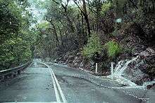
Galston Gorge

Galston Gorge is part of the picturesque Berowra Valley Regional Park in Sydney, Australia and separates Galston from Hornsby Heights. It contains a narrow stretch of road with a one-way wooden bridge across Tunks Creek, a tributary of Berowra Creek. Here traffic must wait for cars already on the bridge before crossing. A second bridge in the gorge crosses Berowra Creek itself.[1]
During heavy rain the Gorge is often transformed into a far more picturesque and natural drive with waterfalls and streams running alongside and sometimes even across the road. Care must be taken by commuters to drive carefully during wet weather for this heavy run-off can cause a car to slip into the guard rail. The entire length of the Gorge is enclosed by this guard rail on the Berowra Creek side of the road to stop a sliding car from falling down the steep slope. Recently a roundabout was installed on the Galston side of the Gorge to give heavy vehicles like Buses and Semi's a chance to turn around, for they are far too long to navigate the tight hairpin turns in the Gorge. In the past the Gorge has had to have been closed for extended periods of time due to a long vehicle becoming stuck. This causes massive disruption to commuters in both Galston and Hornsby as the only other way across is via Boundary Road. From Galston to Hornsby Heights via the Gorge takes approximately 20–25 minutes whereas the same route via Boundary Road takes approximately 40–45 minutes, depending on traffic. During peak hour it can be as long as 1 hour and 20 minutes.
There are three designated car park spots for nearby bush walks close to the road at the foot of the valley as well as room beside the road between the two bridges where two or three cars could feasibly park. There are six hairpin turns in the gorge, the first and last of them are the most gentle, however the three in between are tight. Vehicles with turning circles of 11m or less can make the turn without the need to swing onto the other side of the road. Those drivers that require to use the other side of the road need to do this before the bend when there is no oncoming traffic or wait at the cusp of the bend until there is room for them to do so. Drivers can not assume they can use both lanes without first confirming safe passage. Inexperienced gorge drivers sometimes do neither of these and can become stuck between oncoming traffic and following vehicles, leading to a traffic jam until someone can reverse. This, coupled with the often narrow road precariously close to the rock beside the road - particularly going up to Galston side means the road has a fairly notorious reputation. Other than the hairpin turns, it is imperative that all vehicles remain within the drawn lines of their lane to prevent head-on accidents. There are, of course, other Sydney roads more difficult for driving than Galston Gorge, but there are fewer places in Sydney where there is such a large flow of cars during peak hour. There is a lack of suitable public transport for residents travelling from the Galston side of the gorge through to Hornsby as buses are too long to negotiate the hairpin turns. Therefore, residents of Sydney's mostly rural expanding north-west are forced to drive through the gorge or take other public transport options which add considerable time to the trip when travelling to North Shore or city business districts.
Before 2000, a population of feral chickens lived in the bushland. This population was boosted from time to time by local residents, who would leave chickens from their semi-rural properties on the Galston side of the gorge at the bottom of the valley. Steps were taken by Hornsby Shire Council to eradicate this population, however the chickens seem to have bounced back and can often be seen wandering around in the three parking spaces available at the base of the gorge.
The Gorge is also home to many native birds, mammals and reptiles. Commuters must take extra care when driving at night for possums and other nocturnal animals may be crossing the road and with the tight turns and poor visibility it can be a challenge to spot them in time.
References
- ↑ "Bushwalking on the Thornleigh to Galston Gorge hiking trail". Retrieved 2008-12-05.
Coordinates: 33°39′55″S 151°04′46″E / 33.6653°S 151.0794°E
