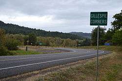
Gillespie Corners, Oregon
| Gillespie Corners | |
|---|---|
| Unincorporated community | |
 | |
 Gillespie Corners  Gillespie Corners Location within the state of Oregon | |
| Coordinates: 43°54′38″N 123°14′57″W / 43.91056°N 123.24917°WCoordinates: 43°54′38″N 123°14′57″W / 43.91056°N 123.24917°W | |
| Country | United States |
| State | Oregon |
| County | Lane |
| Time zone | Pacific (PST) (UTC-8) |
| • Summer (DST) | PDT (UTC-7) |
Gillespie Corners is a road junction and unincorporated locale in Lane County, Oregon, United States.[1][2] Gillespie Corners lies at the intersection of Territorial Highway and Lorane Highway, southeast of Eugene.
The locale was named for brothers Marcellus and Walter Gillespie, grandsons of pioneer Jacob Gillespie, who was a member of the Oregon Territorial Legislature and the namesake for Gillespie Butte north of Eugene.[3]
References
- ↑ "Feature Query Results". United States Board on Geographic Names, United States Geological Survey. Retrieved July 29, 2008.
- ↑ "Feature Class Types". Geographic Names Information System, United States Geological Survey. Archived from the original on June 2, 2008. Retrieved July 29, 2008.
- ↑ Jan (June 6, 2008). "Marcellus Melanthon "Cel" Gillespie, Jr". Find a Grave. Retrieved February 25, 2015.
External links
- Restore Oregon application for 2012 Oregon's Most Endangered Places for Lorane Elementary School, includes history of Gillespie Corners
This article is issued from Wikipedia - version of the 9/11/2016. The text is available under the Creative Commons Attribution/Share Alike but additional terms may apply for the media files.
