Guadalupe National Forest
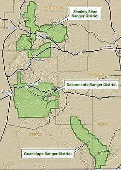
Map of Lincoln National Forest
Guadalupe National Forest was established by the U.S. Forest Service in New Mexico on April 19, 1907. On July 1, 1908, the entire forest was combined with Sacramento National Forest to create Alamo National Forest.[1]
The lands are presently part of the Guadalupe District of Lincoln National Forest. The district comprises the Guadalupe Mountains to the north of Carlsbad Caverns and Guadalupe Mountains National Parks.[2]
References
- ↑ Davis, Richard C. (September 29, 2005). "National Forests of the United States" (pdf). The Forest History Society.
- ↑ "About Us". Lincoln National Forest. U.S. Forest Service. 2008-08-25.
External links
- Lincoln National Forest
- Forest History Society
- Listing of the National Forests of the United States and Their Dates (Forest History Society website) Text from Davis, Richard C., ed. Encyclopedia of American Forest and Conservation History. New York: Macmillan Publishing Company for the Forest History Society, 1983. Vol. II, pp. 743-788.
Coordinates: 32°18′00″N 104°51′00″W / 32.30000°N 104.85000°W
This article is issued from Wikipedia - version of the 7/15/2015. The text is available under the Creative Commons Attribution/Share Alike but additional terms may apply for the media files.
