Hardthausen am Kocher
| Hardthausen am Kocher | ||
|---|---|---|
|
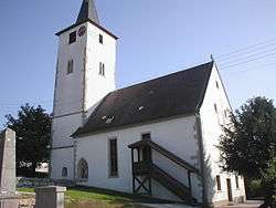
Church in Lampoldshausen | ||
| ||
 Hardthausen am Kocher | ||
Location of Hardthausen am Kocher within Heilbronn district 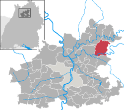 | ||
| Coordinates: 49°14′N 9°24′E / 49.233°N 9.400°ECoordinates: 49°14′N 9°24′E / 49.233°N 9.400°E | ||
| Country | Germany | |
| State | Baden-Württemberg | |
| Admin. region | Stuttgart | |
| District | Heilbronn | |
| Government | ||
| • Mayor | Harry Brunnet | |
| Area | ||
| • Total | 35.55 km2 (13.73 sq mi) | |
| Population (2015-12-31)[1] | ||
| • Total | 4,094 | |
| • Density | 120/km2 (300/sq mi) | |
| Time zone | CET/CEST (UTC+1/+2) | |
| Postal codes | 74239 | |
| Dialling codes | 07139 | |
| Vehicle registration | HN | |
| Website | www.hardthausen.de | |

Hardthausen am Kocher is a town in the district of Heilbronn in Baden-Württemberg in southern Germany.
Geography
Location
Hardthausen lies in the east of the county of Heilbronn in the lower Kocher valley on the southern edge of the Harthausen Forest.
References
| Wikimedia Commons has media related to Hardthausen am Kocher. |
This article is issued from Wikipedia - version of the 12/30/2015. The text is available under the Creative Commons Attribution/Share Alike but additional terms may apply for the media files.
