Harrison Township, Blackford County, Indiana
| Harrison Township | |
|---|---|
| Township | |
|
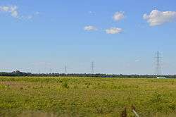
Along State Road 18 west of Montpelier | |
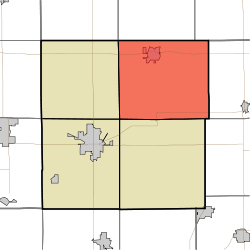 Location of Harrison Township in Blackford County | |
| Coordinates: 40°31′49″N 85°16′07″W / 40.53028°N 85.26861°WCoordinates: 40°31′49″N 85°16′07″W / 40.53028°N 85.26861°W | |
| Country | United States |
| State | Indiana |
| County | Blackford |
| Government | |
| • Type | Indiana township |
| Area | |
| • Total | 42.23 sq mi (109.4 km2) |
| • Land | 42.13 sq mi (109.1 km2) |
| • Water | 0.1 sq mi (0.3 km2) |
| Elevation[1] | 879 ft (268 m) |
| Population (2010) | |
| • Total | 2,640 |
| • Density | 62.7/sq mi (24.2/km2) |
| FIPS code | 18-31630[2] |
| GNIS feature ID | 453378 |
Harrison Township is one of four townships in Blackford County, Indiana. As of the 2010 census, its population was 2,640 and it contained 1,196 housing units.[3] The township was named after William Henry Harrison, hero of the Battle of Tippecanoe, former governor of the Indiana Territory, and ninth President of the United States.[4]
Geography
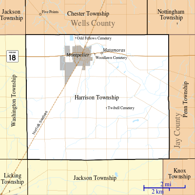
According to the 2010 census, the township has a total area of 42.23 square miles (109.4 km2), of which 42.13 square miles (109.1 km2) (or 99.76%) is land and 0.1 square miles (0.26 km2) (or 0.24%) is water.[3] Lake Blue Water and the Godfrey Reserve are in this township. The Salamonie River runs through the township's northeast corner.
Cities and towns
Unincorporated towns
Major highways
Cemeteries
The township contains at least eight cemeteries: Brookside, Independent Order of Odd Fellows, North Twibell, Penrod, Pleasantdale, South Twibell, St Margaret's Roman Catholic, and Woodlawn.
Notes
- ↑ "US Board on Geographic Names". United States Geological Survey. 2007-10-25. Retrieved 2008-01-31.
- ↑ "American FactFinder". United States Census Bureau. Retrieved 2008-01-31.
- 1 2 "Population, Housing Units, Area, and Density: 2010 - County -- County Subdivision and Place -- 2010 Census Summary File 1". United States Census. Retrieved 2013-05-10.
- ↑ See “A History of Blackford County, Indiana…”, page 112.
References
- "Harrison Township, Blackford County, Indiana". Geographic Names Information System. United States Geological Survey. Retrieved 2009-09-24.
- A History of Blackford County, Indiana : with historical accounts of the county, 1838-1986 [and] histories of families who have lived in the county. Hartford City, Indiana: Blackford County Historical Society. 1986. p. 302. OCLC 15144953.
- Biographical and historical record of Jay and Blackford Counties, Indiana: Containing ... portraits and biographies of some of the prominent men of the state : engravings of prominent citizens in Jay and Blackford Counties, with personal histories of many of the leading families and a concise history of Jay and Blackford Counties and their cities and villages. Chicago: The Lewis Publishing Company. 1887. p. 901. OCLC 15560416.
- U.S. Board on Geographic Names
- United States Census Bureau cartographic boundary files
External links

Municipalities and communities of Blackford County, Indiana, United States | ||
|---|---|---|
| Cities | ||
| Town | ||
| Townships | ||
| Unincorporated communities | ||
| Footnotes | ‡This populated place also has portions in an adjacent county or counties | |