Hiruzen
| Hiruzen | |
|---|---|
| 蒜山 | |
|
Hiruzen viewed from the Hiruzen Plateau, with Kamihiruzen at center and Nakahiruzen to the right | |
| Highest point | |
| Elevation | 1,202 m (3,944 ft) |
| Coordinates | 35°19′30″N 133°39′49″E / 35.32500°N 133.66361°ECoordinates: 35°19′30″N 133°39′49″E / 35.32500°N 133.66361°E |
| Naming | |
| Pronunciation | Japanese: [hiɽuzeɴ] |
| Geography | |
 Hiruzen | |
| Parent range | Chūgoku Mountains |
| Climbing | |
| Easiest route | Hiking |
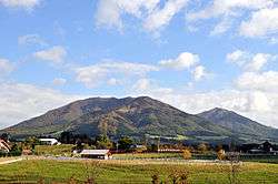
Hiruzen (蒜山), or Hiruzensanza (蒜山三座), is a mountain located on the border of Okayama and Tottori prefectures on the main island of Honshu in Japan. Hiruzen consists of three peaks of similar elevation, the highest being Mt. Kamihiruzen (Hiruzen (上蒜山)) at 1,202 m (3,944 ft).[1] The Hiruzen Plateau, also called the Hiruzen Highland, is located entirely in Okayama Prefecture, and has an elevation of 500 metres (0.31 mi) to 600 metres (0.37 mi).[2] Hiruzen is an important part of the Daisen-Oki National Park.[3][4]
Etymology
The name of Hiruzen in the Japanese language is formed from two kanji characters, 蒜, meaning garlic, and 山, meaning "mountain".
Peaks
The three peaks of Hiruzen are commonly known as the Hiruzen Sanza (蒜山三座),[1] or the "three seats of Hiruzen". They run from west to east and include:
- Kamihiruzen (上蒜山), 1,202 kilometres (747 mi), translated as "upper Hiruzen"
- Nakahiruzen (中蒜山), 1,122 kilometres (697 mi), or "central Hiruzen"
- Shimohiruzen (下蒜山), 1,101 kilometres (684 mi), or "lower Hiruzen".[1][4][5][6]
History
Mount Hiruzen has been settled from the Japanese stone age. Remains from the Jōmon period (14,000–300 BCE) are scattered across the Hiruzen and Ōbagun Basins. The Yayoi period (300 BCE–250 CE) saw a great population increase to the area south of Hiruzen. The Hiruzen Basin is home to six kofun burial mound groups, each featuring a medium-size round kofun of approximately 10 to 30 meters. The kofun groups of the Hiruzen Basin date to the late 5th century. By the Kamakura period (1185 – 1333) the Hiruzen Basin had become the northernmost point of the domain of the Tokuyama clan. In the Sengoku period (1467 – 1573) the Hiruzen region was contested by the Yamana, Akamatsu, Miura and other clans. After the establishment of the Tokugawa shogunate in 1603, the area was ruled peacefully under direct control of the shogunate, the Mori clan, the Matsudaira clan, and others.[7]
Geography
Hiruzen is a dormant, but not extinct, volcano located to the southeast of Mount Daisen.[1] The three peaks of Hiruzen, along with a few smaller peaks, form the Hiruzen volcanic belt, a subset of the Daisen volcanic belt.[3][5] An eruption of Daisen occurred approximately 350,000 years ago, and created a 200 hectares (490 acres) lake, known as Lake Hiruzenbara, above the Hiruzen Plateau. The lake supported an extensive population of diatoms for nearly 50,000 years, and Diatomaceous soil on the plain reaches 100 metres (330 ft) deep in some areas. Lake Hiruzenbara was gradually eroded on its eastern perimeter by the Asahi River, and dried up and disappeared over time.[8]
Hiruzen Plateau
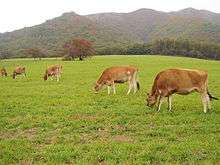
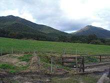
The Hiruzen Plateau, known in Japanese as either the 蒜山高原 (Hiruzen Kōgen) or 蒜山原 (Hiruzen-bara),[1][6] is located entirely in Okayama Prefecture at the southern foot of Hiruzen. The plateau has an elevation of 500 metres (1,600 ft) to 600 metres (2,000 ft) and measures 20 kilometres (12 mi) east to west and 10 kilometres (6.2 mi) north to south.[2][5] The plateau and its surrounding areas have been developed for recreation, specifically skiing and camping. Hiruzen Jersey Land, a Jersey cattle ranch, is also located on the plateau. Hiruzen Horse Park offers horseback riding on the plateau.[4][9]
Asahi River
The Hiruzen Plateau is the source of the Asahi River, which flows 142 kilometres (88 mi) from Hiruzen south across the Okayama Plain, and empties into Kojima Bay on the Inland Sea in the eastern part of Okayama City. The Shiogama-reisen Cold Spring is designated as the source of the river, and is a protected natural habitat of the Japanese giant salamander.[10] Yubara Dam, on the upper reaches of the Asahi, is approximately 12 kilometres (7.5 mi) from Hiruzen and was completed in 1952. The dam forms an artificial lake, Lake Yubara (455 hectares (1,120 acres)), directly to the southeast of the Hiruzen Plateau.[3][11][12] The Hiruzen Plateau has also developed recreational facilities for camping, skiing, and fishing.[2]
Hiking
After Daisen, Hiruzen is the most visited mountain in Tottori Prefecture.[2] Hiruzen is a popular hiking destination. All three peaks are suitable for beginning climbers. The summit of Kamihiruzen and Nakahiruzen can be reached in approximately two hours, and Shimohiruzen in one hour and forty minutes.[6]
External links
References
- 1 2 3 4 5 "Hiruzen". Dijitaru daijisen (in Japanese). Tokyo: Shogakukan. 2012. Retrieved 2012-05-23.
- 1 2 3 4 "Hiruzen Kōgen". Encyclopedia of Japan. Tokyo: Shogakukan. 2012. Retrieved 2012-05-23.
- 1 2 3 "Hiruzen". Nihon Daihyakka Zensho (Nipponika) (in Japanese). Tokyo: Shogakukan. 2012. Retrieved 2012-05-20.
- 1 2 3 "Hiruzen Highland". Tokyo: Japan-i. 2008. Retrieved June 21, 2012.
- 1 2 3 "Hiruzen". Nihon Rekishi Chimei Taikei (in Japanese). Tokyo: Shogakukan. 2012. Retrieved 2012-05-24.
- 1 2 3 "Hiruzen Kōgen e yokoso!" [Welcome to Hiruzen Highland] (in Japanese). Retrieved 2012-05-26.
- ↑ "大庭郡" [Ōba District]. Nihon Rekishi Chimei Taikei (in Japanese). Tokyo: Shogakukan. 2012. OCLC 173191044. dlc 2009238904. Retrieved 2012-05-25.
- ↑ 蒜山高原の誕生 [Origin of the Hiruzen Plain] (in Japanese). Maniwa, Okayama Prefecture, Japan: Hiruzen Kankō Kyōkai. c. 2012. Retrieved June 21, 2012.
- ↑ "Hiru-zen". Nihon Kokugo Daijiten (in Japanese). Tokyo: Shogakukan. 2012. Retrieved 2012-05-24.
- ↑ "Hiruzen-kogen Highlands". Tokyo, Japan: Japan National Tourism Organization. c. 2012. Retrieved June 21, 2012.
- ↑ "Asahigawa". Encyclopedia of Japan. Tokyo: Shogakukan. 2012. Retrieved 2012-05-24.
- ↑ "Asahi-gawa". Dijitaru daijisen (in Japanese). Tokyo: Shogakukan. 2012. Retrieved 2012-05-24.
