Hokuto, Hokkaido
| Hokuto 北斗市 | ||
|---|---|---|
| City | ||
| ||
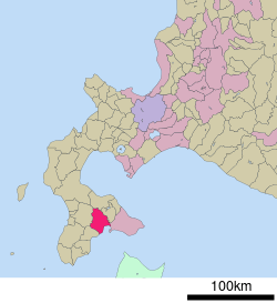
 Location of Hokuto in Hokkaido (Oshima Subprefecture) | ||
 Hokuto Location in Japan | ||
| Coordinates: 41°49′N 140°39′E / 41.817°N 140.650°ECoordinates: 41°49′N 140°39′E / 41.817°N 140.650°E | ||
| Country | Japan | |
| Region | Hokkaido | |
| Prefecture | Hokkaido (Oshima Subprefecture) | |
| Government | ||
| • Mayor | Toshimine Takaya | |
| Area | ||
| • Total | 397.29 km2 (153.39 sq mi) | |
| Population (March 31, 2008) | ||
| • Total | 49,452 | |
| • Density | 125/km2 (320/sq mi) | |
| Symbols | ||
| • Tree | Japanese Black Pine and Japanese beech | |
| • Flower |
Spring: Sakura Summer: Marigold Autumn: Mukuge | |
| Time zone | Japan Standard Time (UTC+9) | |
| City hall address |
1-3-10 Chūō, Hokuto-shi, Hokkaidō 049-0192 | |
| Website |
www | |
Hokuto (北斗市 Hokuto-shi) is a city in the center of the Oshima Subprefecture in Japan's northern island of Hokkaido.[1] It serves as a bedroom community for Hakodate, to the east of the city.[2] Hokuto was formed on February 1, 2006 from merging the town of Kamiiso, from Kamiiso District, and the town of Ōno, from Kameda District. Hokuto is the third city to be established in Oshima. (The second, Kameda City, no longer exists being dissolved just two years after its founding in 1971.) Hokuto is the second largest city in Oshima by population after Hakodate.[1]
Geography
Hokuto is in the middle of Oshima, a peninsula in Hokkaido's south. The southeast portion is mostly plains and the western part is more mountainous. The south borders the Hakodate Bay. The Ōno River runs north and south through the middle of Hokuto.
- Mountain: Katsuratake (734m)
- Rivers: Ōno, Hekirichi
- Lake: Kamiiso
- Forest parks: Hachirounuma Koen
Neighboring regions
- Oshima Subprefecture
- Hakodate City
- Kamiiso District: Kikonai Town
- Kameda District: Nanae Town
- Kayabe District: Mori Town
- Hiyama Subprefecture
History
- 1900 Kamiiso village and Ono village were founded.
- 1918 Kamiiso village became Kamiiso town.
- 1955 Mobetsu village was merged into Kamiiso town.
- 1957 Ono village became Ono town.
- 2006 Kamiiso town and Ono town were merged to form Hokuto city.
Transportation
Rail
Oshima-Ōno Station is scheduled to be rebuilt and renamed Shin-Hakodate-Hokuto Station by the time the Hokkaido Shinkansen in March 2016.
- Esashi Line: Nanaehama - Higashi-Kunebetsu - Kunebetsu - Kiyokawaguchi - Kamiiso - Moheji - Oshima-Tōbetsu
- Hakodate Main Line: Oshima-Ōno
Road
- Hakodate-Esashi Expressway: Hokuto-Oiwake IC - Hokuto-Chuo IC - Hokuto-Tomigawa IC - Hokuto-Moheji IC
Education
High schools
- Hokkaido Kamiiso High School
- Hokkaido Ono Agricultural High School
- Hokkaido Hakodate fisheries High School
References
- 1 2 "北斗(市)" [Hokuto]. Nihon Daihyakka Zensho (Nipponika) (in Japanese). Tokyo: Shogakukan. 2012. OCLC 153301537. Retrieved 2012-12-02.
- ↑ "上磯" [Kamiiso]. Nihon Daihyakka Zensho (Nipponika) (in Japanese). Tokyo: Shogakukan. 2012. OCLC 153301537. Retrieved 2012-12-02.
External links
 Hokuto (Hokkaido) travel guide from Wikivoyage
- (Japanese) Official website
