Huron County, Ontario
| Huron County | |
|---|---|
| County (upper-tier) | |
| County of Huron | |
|
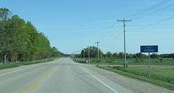
Entering Huron County on Highway 21 | |
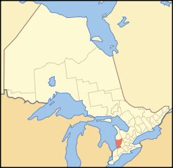
 Huron County's location in relation to Ontario | |
| Coordinates: 43°40′N 81°24′W / 43.667°N 81.400°WCoordinates: 43°40′N 81°24′W / 43.667°N 81.400°W | |
| Country |
|
| Province |
|
| County seat | Goderich |
| Municipalities | |
| Area[1] | |
| • Land | 3,399.63 km2 (1,312.60 sq mi) |
| Population (2011)[1] | |
| • Total | 59,100 |
| • Density | 17.4/km2 (45/sq mi) |
| Time zone | EST (UTC-5) |
| • Summer (DST) | EDT (UTC-4) |
| Postal code span | N0G, N0M, N7A |
| Website |
www |
Huron County is a county of the province of Ontario, Canada. It is located on the southeast shore of its namesake, Lake Huron, in the southwest part of the province. The county seat is Goderich, also the county's largest settlement.
Subdivisions
Town
Townships/Municipalities
- Ashfield–Colborne–Wawanosh
- Bluewater
- Central Huron
- Howick
- Huron East
- Morris-Turnberry
- North Huron
- South Huron
The boundaries of the county's municipalities have been in effect since 2001, after the provincial government imposed mergers throughout the province.
Demographics
Huron County comprises a single Statistics Canada census division.
| Canada census – Huron County, Ontario community profile | |||
|---|---|---|---|
| 2011 | 2006 | 2001 | |
| Population: | 59,100 (-0.4% from 2006) | 59,325 (-0.6% from 2001) | 59,701 (-0.9% from 1996) |
| Land area: | 3,399.63 km2 (1,312.60 sq mi) | 3,396.68 km2 (1,311.47 sq mi) | 3,407.62 km2 (1,315.69 sq mi) |
| Population density: | 17.4/km2 (45/sq mi) | 17.5/km2 (45/sq mi) | 17.5/km2 (45/sq mi) |
| Median age: | 42.3 (M: 41.5, F: 43.1) | 39.8 (M: 39.0, F: 40.6) | |
| Total private dwellings: | 28,049 | 26,922 | 26,330 |
| Median household income: | |||
| References: 2011[2] 2006[3] 2001[4] | |||
Historic populations:[4]
- Population in 2001: 59,701
- Population in 1996: 60,220
Communities
|
|
Former communities/ghost towns
- Donnybrook
- Francistown
- Mafeking
- McGaw
- Sodom
- Spidertown (border with Middlesex County)
See also
References
- 1 2 "Huron County census profile". 2011 Census of Population. Statistics Canada. Retrieved 2012-03-26.
- ↑ "2011 Community Profiles". Canada 2011 Census. Statistics Canada. July 5, 2013. Retrieved 2012-03-26.
- ↑ "2006 Community Profiles". Canada 2006 Census. Statistics Canada. March 30, 2011. Retrieved 2012-03-26.
- 1 2 "2001 Community Profiles". Canada 2001 Census. Statistics Canada. February 17, 2012. Retrieved 2012-03-26.
External links
| Wikimedia Commons has media related to Huron County, Ontario. |
- Huron County government site
- Huron County Tourism website
- Blyth Festival Theatre site
- Huron County's Historic Bridges
- Grand Bend Strip community newspaper - serving south Huron County
 |
Bruce County | Grey County |  | |
| Lake Huron | |
Wellington County Perth County | ||
| ||||
| | ||||
| Lambton County | Middlesex County |
This article is issued from Wikipedia - version of the 11/11/2016. The text is available under the Creative Commons Attribution/Share Alike but additional terms may apply for the media files.
