Indiana State Road 28
| ||||
|---|---|---|---|---|
 | ||||
| Route information | ||||
| Maintained by INDOT | ||||
| Length: | 152.8 mi[1] (245.9 km) | |||
| Existed: | October 1, 1926[2] – present | |||
| Major junctions | ||||
| West end: |
 IL 119 west of West Lebanon IL 119 west of West Lebanon | |||
|
 US 27 in Deerfield US 27 in Deerfield | ||||
| East end: |
 SR 571 in Union City SR 571 in Union City | |||
| Location | ||||
| Counties: | Warren, Fountain, Tippecanoe, Clinton, Tipton, Madison, Delaware, Randolph | |||
| Highway system | ||||
| ||||

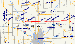
State Road 28 is an east–west road in central Indiana in the United States that crosses the entire state from east to west, covering a distance of about 153 miles (246 km) and passing about 20 miles (32 km) to the north of the state capitol of Indianapolis.
Route description
The western terminus of State Road 28 is at the Illinois state line where it continues the route of Illinois Route 119, about 7.5 miles (12.1 km) west of West Lebanon. The eastern terminus is at the Ohio state line where Ohio State Route 571 continues the route, near State Road 32 in the border-town of Union City. For most of its length it is an undivided two-lane road which mainly travels through flat, open farm land, avoiding the hillier and more wooded areas that begin not far to the south. It is divided for about 1 mile (1.6 km) just west of Frankfort, where it passes the Frankfort Municipal Airport.[3]
State Road 28 has concurrencies with four U.S. routes, as well as four other Indiana state roads; these are described below.
Major intersections
| County | Location | mi[1] | km | Destinations | Notes |
|---|---|---|---|---|---|
| Warren | Steuben Township | 0.00 | 0.00 | IL 119 west | Western terminus of SR 28 at Illinois state line |
| Pike Township | 6.64 | 10.69 |  SR 63 – Terre Haute, Hammond SR 63 – Terre Haute, Hammond | ||
| West Lebanon | 7.56 | 12.17 |  SR 263 – West Lebanon SR 263 – West Lebanon | ||
| Williamsport | 14.11 | 22.71 |  US 41 north – Hammond US 41 north – Hammond | Western end of US 41 concurrency | |
| Attica |  SR 55 north – Fowler SR 55 north – Fowler | Western end of SR 55 concurrency | |||
| Fountain | 16.85 | 27.12 | US 41 south / SR 55 south – Rockville, Newtown | Eastern end of US 41 and SR 55 concurrences | |
| Davis Township | 22.19 | 35.71 |  SR 341 south – Newtown SR 341 south – Newtown | Northern terminus of SR 341 | |
| Tippecanoe | Odell | 26.15 | 42.08 |  SR 25 south – Waynetown SR 25 south – Waynetown | Southern end of SR 25 concurrency |
| 26.66 | 42.91 | SR 25 north – Lafayette | Northern end of SR 25 concurrency | ||
| Romney | 37.38 | 60.16 |  US 231 – Crawfordsville, Lafayette US 231 – Crawfordsville, Lafayette | ||
| Lauramie Township | 47.78 | 76.89 |  US 52 north – Lafayette US 52 north – Lafayette | Western end of US 52 concurrency | |
| 48.32 | 77.76 | US 52 south – Indianapolis | Eastern end of US 52 concurrency | ||
| Clinton | Washington Township | 50.84 | 81.82 |  I-65 – Indianapolis, Lafayette, Gary I-65 – Indianapolis, Lafayette, Gary | |
| Frankfort | 58.76 | 94.57 |    US 421 north / SR 38 / SR 39 – Delphi, Lebanon, Noblesville US 421 north / SR 38 / SR 39 – Delphi, Lebanon, Noblesville | Western end of US 421 concurrency | |
| Michigan Township |  SR 29 north – Logansport SR 29 north – Logansport | Southern terminus of SR 29 | |||
| 65.43 | 105.30 | US 421 south | Eastern end of US 421 concurrency | ||
| Tipton | Jefferson Township | 79.58 | 128.07 |  US 31 – Indianapolis, Kokomo, South Bend US 31 – Indianapolis, Kokomo, South Bend | |
| Tipton | 84.25 | 135.59 |  SR 19 south – Noblesville SR 19 south – Noblesville | Western end of SR 19 concurrency | |
| 84.76 | 136.41 | SR 19 north – Peru | Eastern end of SR 19 concurrency | ||
| Hobbs | 88.70 | 142.75 |  SR 213 – Noblesville, Greentown SR 213 – Noblesville, Greentown | ||
| Madison | Elwood | 94.82 | 152.60 |  SR 13 – Fortville, Wabash SR 13 – Fortville, Wabash | |
| 96.54 | 155.37 |  SR 37 – Noblesville, Marion SR 37 – Noblesville, Marion | |||
| Alexandria | 103.82 | 167.08 |  SR 9 – Anderson, Marion SR 9 – Anderson, Marion | ||
| Delaware | Harrison Township | 109.79 | 176.69 |   I-69 north / US 35 – Indianapolis, Fort Wayne I-69 north / US 35 – Indianapolis, Fort Wayne | Western end of US 35 concurrency |
| Hamilton Township | 119.80 | 192.80 |  US 35 south / SR 3 – Muncie, Hartford City US 35 south / SR 3 – Muncie, Hartford City | Eastern end of US 35 concurrency | |
| Delaware Township | 122.52 | 197.18 |  SR 67 south – Muncie SR 67 south – Muncie | Western end of SR 67 concurrency | |
| Albany | 126.71 | 203.92 | SR 67 – north, Portland | Eastern end of SR 67 concurrency | |
| Randolph | Green Township | 132.15 | 212.67 |  SR 1 – Cambridge, Bluffton SR 1 – Cambridge, Bluffton | |
| Deerfield | 141.80 | 228.20 | US 27 – Winchester, Decatur, Fort Wayne | ||
| Union City | 152.61 | 245.60 |  SR 32 east SR 32 east
 To SR 47 east – Union City To SR 47 east – Union City | Northern end of SR 32 concurrency | |
| 152.72 | 245.78 | SR 32 west – Winchester | Southern end of SR 32 concurrency | ||
| 152.80 | 245.91 | SR 571 east – Greenville | Eastern terminus of SR 28 at the Ohio State Line | ||
1.000 mi = 1.609 km; 1.000 km = 0.621 mi
| |||||
Attractions
References
- 1 2 "INDOT Roadway Referencing System" (PDF).
- ↑ "Road Numbers to Be Changed". The Hancock-Democrat. The Indianapolis News. September 30, 1926. Retrieved June 9, 2016 – via Newspapers.com.

- ↑ Google (2007-09-21). "Indiana State Road 28" (Map). Google Maps. Google. Retrieved 2007-09-21.