Interstate 295 (Virginia)
| ||||
|---|---|---|---|---|
_map.svg.png) | ||||
| Route information | ||||
| Maintained by VDOT | ||||
| Length: | 52.75 mi[1][2][3][4] (84.89 km) | |||
| Existed: | late 1980s – present | |||
| Major junctions | ||||
| South end: |
 I‑95 near Petersburg I‑95 near Petersburg | |||
| ||||
| North end: |
 I‑64 near Short Pump I‑64 near Short Pump | |||
| Highway system | ||||
| ||||


Interstate 295 (I-295) is an eastern and northern bypass of the cities of Richmond and Petersburg in the U.S. state of Virginia. The southern terminus is an interchange with I-95 southeast of Petersburg. I-295 then has an interchange with I-64 east of Richmond, crosses I-95 north of Richmond, and continues westward to its other terminus at a second interchange with I-64.
Route description
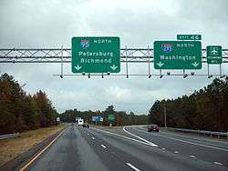
In effect, I-295 serves as a bypass route for both I-64 and I-95. It also performs crossover duty for travelers between Washington, D.C. (reached by I-95) and southeastern Virginia (reached by I-64), and links many of Richmond's suburbs (such as Short Pump, Mechanicsville, Highland Springs, Varina, and Hopewell). Much of the highway has a posted speed limit of 70 miles per hour (110 km/h). The highway carries two lanes from its southern terminus to exit 9 (SR 36), three lanes from exit 9 to exit 28 (I-64) four lanes from exit 28 to exit 43 (I-95) and three lanes again from exit 43 to its northern terminus. All of the exits are cloverleafs with the exceptions of: its southern terminus I-95 (exit 1), Meadowville Technology Parkway (exit 16), SR 895 (exit 25) and the northern terminus with I-64 (exit 53).
While the route is officially labeled north-south, directional markers are absent from the road between exits 43-53, as the official "north" direction of the road for this section actually travels southwest. Additionally, as the road's primary purpose is to direct long-distance travel away from downtown Richmond, control cities on guide signs for the road include cities such as Washington, D.C., Charlottesville, and Rocky Mount, North Carolina as destinations. However, the highway goes to none of those cities, but instead uses such destinations to direct long-distance travelers away from the congested areas in downtown Richmond and Petersburg. At one time, Miami, FL was also listed as a control city on some guide signs north of Richmond, but these have been removed or changed.
Bridge
The Varina-Enon Bridge carries I-295 across the James River near Dutch Gap between Chesterfield and Henrico counties. It was opened to traffic in July 1990, and was the second major cable-stayed bridge in the United States.
Exit list
| County | Location | mi | km | Exit[5] | Destinations | Notes |
|---|---|---|---|---|---|---|
| Prince George | | 0.00 | 0.00 | I‑95 south – Emporia, Rocky Mount, NC | Southern terminus; southbound exit and northbound entrance; I-95 exit 46 | |
| | 0.00 | 0.00 | 1 |  I‑95 north to I‑85 – Petersburg I‑95 north to I‑85 – Petersburg | Southbound exit and northbound entrance; I-95 exit 46 | |
| New Bohemia | 3 | 4.8 | 3 |  US 460 – Petersburg, Norfolk US 460 – Petersburg, Norfolk | Signed as exits 3A (east) and 3B (west) | |
| City of Hopewell | 9 |  SR 36 – Fort Lee, Colonial Heights, Petersburg, Hopewell SR 36 – Fort Lee, Colonial Heights, Petersburg, Hopewell | Signed as exits 9A (east) and 9B (west) | |||
| Chesterfield | Chester | 15 |  SR 10 to I‑95 – Chester, Hopewell SR 10 to I‑95 – Chester, Hopewell | Signed as exits 15A (east) and 15B (west) | ||
| Meadowville | 16 |  SR 618 (Rivers Bend Boulevard) / Meadowville Technology Parkway SR 618 (Rivers Bend Boulevard) / Meadowville Technology Parkway | ||||
| James River | Varina-Enon Bridge | |||||
| Henrico | Varina Grove | 22 |  SR 5 – Varina, Charles City SR 5 – Varina, Charles City | Signed as exits 22A (east) and 22B (west) | ||
| | 25 |      SR 895 Toll west to I‑95 – Richmond, Richmond International Airport SR 895 Toll west to I‑95 – Richmond, Richmond International Airport | ||||
| | 28 |  I‑64 / US 60 – Richmond, Norfolk, Virginia Beach, Richmond International Airport, Seven Pines, Bottoms Bridge I‑64 / US 60 – Richmond, Norfolk, Virginia Beach, Richmond International Airport, Seven Pines, Bottoms Bridge | Signed as exits 28A (I-64 east) and 28B (I-64 west / US 60) southbound; I-64 exit 200 | |||
| | 31 |  SR 156 – Highland Springs, Cold Harbor, Richmond International Airport SR 156 – Highland Springs, Cold Harbor, Richmond International Airport | Signed as exits 31A (north) and 31B (south) | |||
| Hanover | | 34 |  SR 615 (Creighton Road) SR 615 (Creighton Road) | Signed as exits 34A (east) and 34B (west) | ||
| Mechanicsville | 37 |  US 360 – Mechanicsville, Tappahannock US 360 – Mechanicsville, Tappahannock | Signed as exits 37A (east) and 37B (west) | |||
| 38 |  SR 627 (Meadowbridge Road / Pole Green Road) SR 627 (Meadowbridge Road / Pole Green Road) | Signed as exits 38A (east) and 38B (west) | ||||
| | 41 |   US 301 / SR 2 – Richmond, Hanover US 301 / SR 2 – Richmond, Hanover | Signed as exits 41A (north) and 41B (south) | |||
| Henrico | | 43A-B | I‑95 – Richmond, Washington, D.C. | Signed as exits 43A (north) and 43B (south); I-95 exit 84 | ||
| Glen Allen | 43C-D |  US 1 – Richmond, Ashland US 1 – Richmond, Ashland | Signed as exits 43C (north) and 43D (south) | |||
| 45 | Woodman Road | Signed as exits 45A (north) and 45B (south) | ||||
| | 49 |  US 33 – Richmond, Montpelier US 33 – Richmond, Montpelier | Signed as exits 49A (west) and 49B (east) | |||
| | 51 | Nuckols Road | Signed as exits 51A (north) and 51B (south) | |||
| | 52.75 | 84.89 | 53 |   I‑64 to SR 288 / US 250 – Richmond, Charlottesville I‑64 to SR 288 / US 250 – Richmond, Charlottesville | Signed as exits 53A (west) and 53B (east); I-64 exit 177 | |
| 1.000 mi = 1.609 km; 1.000 km = 0.621 mi | ||||||
See also
-
 U.S. Roads portal
 -
 Virginia portal
References
- ↑ 2005 Virginia Department of Transportation Jurisdiction Report - Daily Traffic Volume Estimates - Prince George County
- ↑ 2005 Virginia Department of Transportation Jurisdiction Report - Daily Traffic Volume Estimates - Chesterfield County
- ↑ 2005 Virginia Department of Transportation Jurisdiction Report - Daily Traffic Volume Estimates - Henrico County
- ↑ 2005 Virginia Department of Transportation Jurisdiction Report - Daily Traffic Volume Estimates - Hanover County
- ↑ "Virginia Interstate Exits". Virginiadot.org. Retrieved 2011-09-19.
External links
 |
Wikimedia Commons has media related to Interstate 295 (Virginia). |
- I-295 on Kurumi.com
- "Virginia DOT map showing I-295" (PDF). (1.75 MB)
- I-295 on Interstate Guide
| ||
| ||