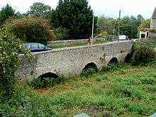
Keynsham Lock

Keynsham Lock is a canal lock situated on the River Avon at Keynsham, England.
The Bristol Avon Navigation, which runs the 15 miles (24 km) from the Kennet and Avon Canal at Hanham Lock to the Bristol Channel at Avonmouth, was constructed between 1724 and 1727,[1] following legislation passed by Queen Anne,[2][3] by a company of proprietors and the engineer John Hore of Newbury. The first cargo of 'Deal boards, Pig-Lead and Meal' arrived in Bath in December 1727.[4] The navigation is now administered by the Canal & River Trust.
The old bridge next to the lock played a part in the Civil War as the Roundheads saved the town and also camped there for the night, using the pub now known as the Lock Keeper's Inn as a guard post.[5] The lock opened in 1727.[6]
Just above the lock are some visitor moorings and a pub, on an island between the lock and the weir. The weir side of the island is also the mouth of the River Chew. The adjacent bridge was replaced after damage in the Great Flood of 1968.[7]
See also
| Wikimedia Commons has media related to Keynsham Lock. |
References
- ↑ "Bristol Avon Navigation". Inland Waterways Association. Retrieved 3 March 2013.
- ↑ "Navigation of the river Avon". Bristol History.com. Archived from the original on 10 January 2007. Retrieved 22 September 2006.
- ↑ Priestley, Joseph (1831). "
 Avon River, Gloucestershire". Historical Account of the Navigable Rivers, Canals, and Railways, of Great Britain. Longman, Rees, Orme, Brown & Green,. Wikisource.
 - ↑ Allsop, Niall (1989). The Kennet & Avon Canal (2 ed.). Millstream Books. p. 4. ISBN 9780948975158.
- ↑ Clark, Pete. "Keynshams part in the Monmouth Rebellion". Keynsham Community Website. Archived from the original on 5 March 2010. Retrieved 30 April 2010.
- ↑ Allsop, Niall (1989). The Kennet & Avon Canal (2 ed.). Millstream Books. p. 17. ISBN 9780948975158.
- ↑ Clew, Kenneth R. (1978). Wessex Waterway. Moonraker Press. p. 60. ISBN 978-0239001818.
| Next lock upstream | River Avon, Bristol / Kennet and Avon Canal | Next lock downstream |
| Swineford Lock | Keynsham Lock Grid reference: ST658690 |
Hanham Lock |
Coordinates: 51°25′11″N 2°29′31″W / 51.41977°N 2.49192°W