Kita-Koshigaya Station
Kita-Koshigaya Station 北越谷駅 | |
|---|---|
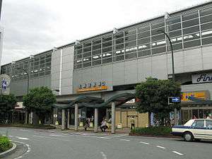
 Kita-Koshigaya Station east exit, June 2012 | |
| Location |
3-4-23 Ōsawa, Koshigaya-shi, Saitama-ken (埼玉県越谷市大沢三丁目4-23) Japan |
| Operated by |
|
| Line(s) |
|
| Distance | 26.0 km from Asakusa |
| Platforms | 2 island platforms |
| Tracks | 4 |
| Connections | Bus terminal |
| Other information | |
| Station code | TS-22 |
| Website |
railway |
| History | |
| Opened | 27 August 1899 |
| Previous names |
|
| Traffic | |
| Passengers (FY2014) | 52,745 daily |
| Location | |
 Kita-Koshigaya Station Location within Japan | |
Kita-Koshigaya Station (北越谷駅 Kita-Koshigaya-eki) is a railway station on the Tobu Skytree Line (Tobu Isesaki Line) in Koshigaya, Saitama, Japan, operated by the private railway operator Tobu Railway.[1]
Lines
Kita-Koshigaya Station is served by the Tobu Skytree Line from Asakusa in Tokyo, and is 26.0 km from the line's terminus at Asakusa.[2] Through services also operate to and from Naka-Meguro via the Tokyo Metro Hibiya Line, and Shibuya and Chūō-Rinkan via the Tokyo Metro Hanzōmon Line and Tokyu Den-en-toshi Line. It is also located adjacent to Minami-Koshigaya Station on the Musashino Line.
Station layout
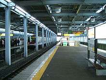
The station consists of two elevated island platforms serving four lines, with the station building located underneath.
Platforms

| Track layout | ||||||||||||||||||||||||||||||||||||||||||||||||||||||||
|---|---|---|---|---|---|---|---|---|---|---|---|---|---|---|---|---|---|---|---|---|---|---|---|---|---|---|---|---|---|---|---|---|---|---|---|---|---|---|---|---|---|---|---|---|---|---|---|---|---|---|---|---|---|---|---|---|
Legend | ||||||||||||||||||||||||||||||||||||||||||||||||||||||||
| ||||||||||||||||||||||||||||||||||||||||||||||||||||||||
| 1 | ■ Tobu Skytree Line | for Kita-Senju, Hikifune, and Asakusa |
| 2 | ■ Tobu Skytree Line | for Kita-Senju, Hikifune, and Asakusa |
| 3 | ■ Tobu Skytree Line | for Kasukabe and Kuki |
| 4 | ■ Tobu Skytree Line | for Kasukabe and Tōbu-Dōbutsu-Kōen |
Adjacent stations
| « | Service | » | ||
|---|---|---|---|---|
| Tobu Skytree Line (TS-22) | ||||
| Limited Express Spacia: Does not stop at this station | ||||
| Limited Express Ryōmō: Does not stop at this station | ||||
| Limited Express Kirifuri: Does not stop at this station | ||||
| Limited Express Shimotsuke: Does not stop at this station | ||||
| Rapid: Does not stop at this station | ||||
| Section Rapid: Does not stop at this station | ||||
| Express: Does not stop at this station | ||||
| Section Express: Does not stop at this station | ||||
| Koshigaya (TS-21) | Semi-Express | Ōbukuro (TS-23) | ||
| Koshigaya (TS-21) | Section Semi-Express | Ōbukuro (TS-23) | ||
| Koshigaya (TS-21) | Local | Ōbukuro (TS-23) | ||
History
The station opened on 27 August 1899 as Koshigaya Station (越ヶ谷駅).[2] It was renamed Bushū-Ōsawa Station (武州大沢駅) on 20 November 1911, and was renamed Kita-Koshigaya from 1 December 1956. From 17 March 2012, station numbering was introduced on all Tobu lines, with Kita-Koshigaya Station becoming "TS-22".[3]
Passenger statistics
In fiscal 2014, the station was used by an average of 52,745 passengers daily.[4]
Surrounding area
- Bunkyo University (Koshigaya Campus)
- Ōsawa Katori Jinja
See also
References
- ↑ "Kita-Koshigaya Station Information" (in Japanese). Japan: Tobu Railway. Retrieved 18 February 2016.
- 1 2 Terada, Hirokazu (19 January 2013). データブック日本の私鉄 [Databook: Japan's Private Railways]. Japan: Neko Publishing. p. 222. ISBN 978-4-7770-1336-4.
- ↑ 「東武スカイツリーライン」誕生! あわせて駅ナンバリングを導入し、よりわかりやすくご案内します [Tobu Sky Tree Line created! Station numbering to be introduced at same time] (pdf). Tobu News (in Japanese). Tobu Railway. 9 February 2012. Retrieved 27 May 2012.
- ↑ 駅情報(乗降人員) [Station information: Passenger figures] (in Japanese). Japan: Tobu Railway. 2015. Retrieved 19 February 2016.
External links
| Wikimedia Commons has media related to Kita-Koshigaya Station. |
- Tobu station information (Japanese)
Coordinates: 35°54′07″N 139°46′48″E / 35.9019°N 139.7800°E
