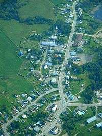
Lac-des-Aigles, Quebec
| Lac-des-Aigles | |
|---|---|
| Municipality | |
 | |
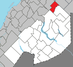 Location within Témiscouata RCM | |
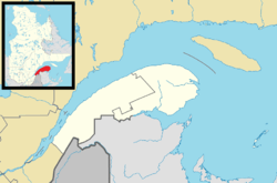 Lac-des-Aigles Location in eastern Quebec | |
| Coordinates: 47°59′00″N 68°41′00″W / 47.9833°N 68.6833°WCoordinates: 47°59′00″N 68°41′00″W / 47.9833°N 68.6833°W[1] | |
| Country |
|
| Province |
|
| Region | Bas-Saint-Laurent |
| RCM | Témiscouata |
| Constituted | January 1, 1948 |
| Government[2] | |
| • Mayor | Claude Breault |
| • Federal riding |
Rimouski-Neigette— Témiscouata—Les Basques |
| • Prov. riding | Rivière-du-Loup-Témiscouata |
| Area[2][3] | |
| • Total | 90.30 km2 (34.87 sq mi) |
| • Land | 87.06 km2 (33.61 sq mi) |
| Population (2011)[3] | |
| • Total | 551 |
| • Density | 6.3/km2 (16/sq mi) |
| • Pop 2006-2011 |
|
| • Dwellings | 284 |
| Time zone | EST (UTC−5) |
| • Summer (DST) | EDT (UTC−4) |
| Postal code(s) | G0K 1V0 |
| Area code(s) | 418 and 581 |
| Highways |
|
Lac-des-Aigles is a municipality in Quebec, Canada.
See also
References
External links
![]() Media related to Lac-des-Aigles, Quebec at Wikimedia Commons
Media related to Lac-des-Aigles, Quebec at Wikimedia Commons
 |
Saint-Guy | Saint-Eugène-de-Ladrière | Esprit-Saint | |
| |
||||
| ||||
| | ||||
| Saint-Michel-du-Squatec | |
Biencourt |
| Cities & Towns | |
|---|---|
| Municipalities | |
| Parishes | |
| |
This article is issued from Wikipedia - version of the 12/1/2016. The text is available under the Creative Commons Attribution/Share Alike but additional terms may apply for the media files.