Liman, Israel
| Liman לִימַן | |
|---|---|
 | |
  Liman | |
| Coordinates: 33°3′32.39″N 35°6′46.44″E / 33.0589972°N 35.1129000°ECoordinates: 33°3′32.39″N 35°6′46.44″E / 33.0589972°N 35.1129000°E | |
| District | Northern |
| Council | Mateh Asher |
| Affiliation | Moshavim Movement |
| Founded | 1949 |
| Founded by | Demobilized soldiers |
| Population (2015)[1] | 729 |
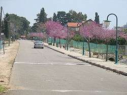
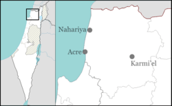
Liman (Hebrew: לִימַן) is a moshav in northern Israel. Located in the Western Galilee about 5 km (3 mi) north of Nahariya, it falls under the jurisdiction of Mateh Asher Regional Council. In 2015 it had a population of 729. Its area is about 2400 dunams and most residents work in agriculture, including chicken raising.
History
The village was founded in 1949 by a group of demobilized soldiers on part of the lands of the depopulated Arab village of al-Bassa. It was originally called Tzahal,[2][3] but was later renamed "Liman" to honor the American senator Herbert H. Lehman.
The Liman Nature Reserve is located about 1 km (1 mi) north of the settlement, an area of about 50 dunams on a section of the gravel ridge that was preserved.
A 3rd century painted tomb from the Roman period was discovered in the fields of Liman in 1994–1995. The tomb contained two skeletons, bottles, coins and pottery.[4]
References
- ↑ "List of localities, in Alphabetical order" (PDF). Israel Central Bureau of Statistics. Retrieved 16 October 2016.
- ↑ Morris, Benny (2004). The Birth of the Palestinian Refugee Problem Revisited. Cambridge University Press. p. xxii. ISBN 978-0-521-00967-6.
- ↑ Khalidi, Walid (1992), All That Remains: The Palestinian Villages Occupied and Depopulated by Israel in 1948, Washington D.C.: Institute for Palestine Studies, p. 9, ISBN 0-88728-224-5
- ↑ Tombs of the Roman Period at Tell Shubeib
External links
- Liman Association for the Development of the Galilee