List of MBTA subway stations
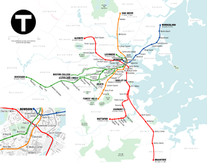
Geographically accurate map of the Boston subway system from 2003; the only permanent change since then has been the opening of Assembly station in 2014.
This is a list of MBTA Subway stations in and around downtown Boston. All stations are operated by the Massachusetts Bay Transportation Authority. This list includes all rapid transit, light rail, and bus rapid transit (BRT) stations currently open on the MBTA's subway system. There are 145 stations on the 5-line system,[1] all of which are located primarily within the Greater Boston area. Boylston and Park Street stations, which opened in 1897, were the first two subway stations in the United States.[2]
Key
| Station | Indicates the MBTA's official name for the station. If the station is handicap accessible in some way, a wheelchair symbol appears next to the station name. (See MBTA accessibility for further details.) |
| Line (Branch) | Indicates the lines that stop at the given station. A boldface line designation indicates that the station is a terminus for that line. When all branches of a line stop at a station, only the line is shown. |
| Connections | Denotes any links to Amtrak trains or the MBTA's Commuter Rail lines at the station. |
| City/neighborhood | Identifies the municipality (or for Boston, the neighborhood) in which the station is located. |
| Station info | A link to the station's information on http://mbta.com. |
Stations
Former stations
Planned stations
| Station | Line (Branch) | Connections | City/neighborhood | Planned opening date | Refs |
|---|---|---|---|---|---|
| Ball Square | Somerville | 2020 | [5] [6] | ||
| College Avenue | Medford | 2020 | [5] [6] | ||
| Gilman Square | Somerville | 2020 | [5] [6] | ||
| Lowell Street | Somerville | 2020 | [5] [6] | ||
| Route 16 | Somerville | >2020 | [7][8] | ||
| Union Square | Somerville | 2017 | [5] [6] | ||
| Washington Street | Somerville | 2017 | [5] [6] |
References
- ↑ http://www.mbta.com/uploadedFiles/documents/Bluebook%202007.pdf
- ↑ "BOSTON'S SUBWAY FINISHED; After Many Protests and Complaints Rapid Transit for the Hub Is Assured. THE COST WAS $5,000,000 Perfection of the Project May Result in the Erection of an Elevated Railroad, Arrangements for Which Have Already Been Made". The New York Times. August 15, 1897.
- 1 2 3 4 5 6 7 8 9 10 11 12 13 14 15 16 17 18 19 20 21 22 23 24 25 26 27 Belcher, Jonathan (19 March 2016). "Changes to Transit Service in the MBTA district" (PDF). NETransit. Retrieved 8 June 2016.
- 1 2 3 4 Daniel, Mac (16 March 2005). "T drops 4 Green Line stops after results of rider survey". Boston Globe. Archived from the original on 18 March 2005. Retrieved 6 February 2014.
- 1 2 3 4 5 6 "Travel Forecasts: Systemwide Stats and SUMMIT Results" (PDF). Green Line Extension Project: FY 2012 New Starts Submittal. Massachusetts Department of Transportation. January 2012. Retrieved 27 January 2015.
- 1 2 3 4 5 6 Phased Project Schedule. Massachusetts Department of Transportation. Accessed 26 July 2015.
- ↑ "Map of the Green Line Extension". Somerville Transportation Equity Partnership. Retrieved 26 July 2015.
- ↑ "Green Line Route 16 funding preserved!". Somerville Transportation Equity Partnership. 3 June 2011. Retrieved 26 July 2015.
External links
| Subway lines (List of stations) |
| |||||||||||
|---|---|---|---|---|---|---|---|---|---|---|---|---|
| Commuter Rail lines (List of stations) |
| |||||||||||
| Bus routes (List of routes) | ||||||||||||
| Other services | ||||||||||||
| Component parts of system lines | ||||||||||||
| Capital projects |
| |||||||||||
| History |
| |||||||||||
| Other | ||||||||||||
This article is issued from Wikipedia - version of the 10/9/2016. The text is available under the Creative Commons Attribution/Share Alike but additional terms may apply for the media files.