Młada Hora
| Młada Hora | |
|---|---|
| Village | |
|
Part of Młada Hora village | |
 Młada Hora | |
| Coordinates: 49°26′26″N 19°5′19″E / 49.44056°N 19.08861°E | |
| Country |
|
| Voivodeship | Silesian |
| County | Żywiec |
| Gmina | Ujsoły |
| Highest elevation | 995 m (3,264 ft) |
| Lowest elevation | 873 m (2,864 ft) |
| Population | 40 |
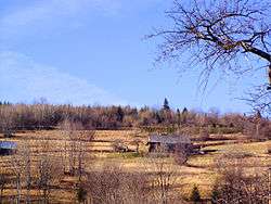
Młada Hora [ˈmwada ˈxɔra] is a village in the administrative district of Gmina Ujsoły, within Żywiec County, Silesian Voivodeship, in southern Poland, close to the border with Slovakia.[1]
Location
It lies approximately 5 kilometres (3 mi) south-west of Ujsoły, 29 km (18 mi) south of Żywiec, and 91 km (57 mi) south of the regional capital Katowice.
Population
The village has a population of 40.
References
| Seat |  | |
|---|---|---|
| Other villages | ||
Coordinates: 49°26′26″N 19°5′19″E / 49.44056°N 19.08861°E
This article is issued from Wikipedia - version of the 10/17/2013. The text is available under the Creative Commons Attribution/Share Alike but additional terms may apply for the media files.