Mardin Province
| Mardin Province Mardin ili | |
|---|---|
| Province of Turkey | |
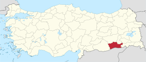
 Location of Mardin Province in Turkey | |
| Country | Turkey |
| Region | Southeast Anatolia |
| Subregion | Mardin |
| Government | |
| • Electoral district | Mardin |
| Area | |
| • Total | 8,891 km2 (3,433 sq mi) |
| Population (2010-12-31)[1] | |
| • Total | 744,606 |
| • Density | 84/km2 (220/sq mi) |
| Area code(s) | 0482 |
| Vehicle registration | 47 |
Mardin Province (Turkish: Mardin ili, Kurdish: Parêzgeha Mêrdînê, Arabic: ماردين,), is a province of Turkey with a population of 744,606. The population was 835,173 in 2000. The capital of the Mardin Province is Mardin (Syriac: ܡܶܪܕܺܝܢ "Mardin" in related Semitic language Arabic: ماردين, Mardīn). Located near the traditional boundary of Anatolia and Mesopotamia, it has a diverse population, composed of Kurdish, Arab and Assyrian people, with Muslims forming the majority of the province's population.[2]
History
Mardin comes from the Syriac word (ܡܪܕܐ) and means "fortresses".[3][4]
The first known civilization were the Subarian-Hurrians who were then succeeded in 3000BCE by the Hurrians. The Elamites gained control around 2230 BCE. and were followed by the Babylonians, Hittites, Assyrians, Romans and Byzantines.[5]
The local Assyrians/Syriacs, while very reduced due to the massacres of the Assyrian Genocide and conflicts between the Kurds and Turks, hold on to two of the oldest monasteries in the world, Dayro d-Mor Hananyo (Turkish Deyrülzafaran, English Saffron Monastery) and Deyrulumur Monastery. The Christian community is concentrated on the Tur Abdin plateau and in the town of Midyat, with a smaller community (approximately 100) in the provincial capital.
Districts

Mardin province is divided into 10 districts (capital district in bold):
- Mardin (Central district, after 2014 it will be named Artuklu)
- Dargeçit
- Derik
- Kızıltepe
- Mazıdağı
- Midyat
- Nusaybin
- Ömerli
- Savur
- Yeşilli
Gallery
- Christian monuments in Mardin Province

 Mor Yuhanun church
 Mar Jacob Church in Nusaybin
- Dayro d-Mor Hananyo monastery
- Islamic monuments in Mardin Province
 Minaret of the grand mosque of Mardin (12th century) and the view of the Mesopotamian plains.
- Kasimiye madrasa (14th century)
 Zinciriye Madrasa (14th century)
- View of Savur and the grand mosque in the center
- Abdullatif mosque (14th century)
References
- ↑ Turkish Statistical Institute, MS Excel document – Population of province/district centers and towns/villages and population growth rate by provinces
- ↑ Watts, Nicole F. (2010). Activists in Office: Kurdish Politics and Protest in Turkey (Studies in Modernity and National Identity). Seattle: University of Washington Press. p. 167. ISBN 978-0-295-99050-7.
- ↑ Lipiński, Edward (2000). The Aramaeans: their ancient history, culture, religion. Peeters Publishers. p. 146. ISBN 978-90-429-0859-8.
- ↑ Payne Smith's A Compendious Syriac Dictionary, Dukhrana.com
- ↑ http://www.tatlidede.com.tr/en/mardin.php
External links
| Wikimedia Commons has media related to Mardin Province. |
- Mardin Weather Forecast Information
- Pictures of the capital of this province
- Articles about the Syriacs and photos of Midyat
- Mardin photos
- Tourism information is available in English at the Southeastern Anatolian Promotion Project site.
- Mardin Travel Guide
Coordinates: 37°21′47″N 40°54′31″E / 37.36306°N 40.90861°E
