Maryland Route 353
| ||||
|---|---|---|---|---|
| Gumboro Road | ||||
|
Maryland Route 353 highlighted in red | ||||
| Route information | ||||
| Maintained by MDSHA | ||||
| Length: | 4.60 mi[1] (7.40 km) | |||
| Existed: | 1927 – present | |||
| Major junctions | ||||
| South end: |
| |||
| North end: |
| |||
| Location | ||||
| Counties: | Wicomico | |||
| Highway system | ||||
| ||||

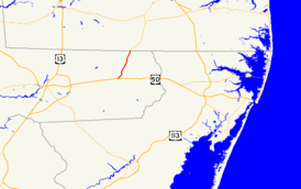
Maryland Route 353 (MD 353) is a state highway in the U.S. state of Maryland. Known as Gumboro Road, the state highway runs 4.60 miles (7.40 km) from MD 346 in Pittsville north to the Delaware state line, where the highway intersects Delaware Route 26 (DE 26) and DE-MD 54. MD 353 was constructed in the mid- to late 1920s.
Route description
MD 353 begins at an intersection with MD 346 (Old Ocean City Road) just south of Pittsville. Sixty Foot Road continues south as a county highway to an intersection with U.S. Route 50 (Ocean Gateway). MD 353 heads northeast as a two-lane road through Pittsville. After intersecting Main Street, the highway turns north past scattered residences. After crossing Aydelotte Branch, MD 353 leaves Pittsville, crossing Burnt Mill Branch and passing through farmland all the way to the highway's northern terminus at the Delaware state line. The roadway continues into Delaware as DE 26 and DE 54 (Millsboro Highway). Bethel Road heads east from the intersection at the state line, while DE-MD 54 (Line Road) follows the state line west to Delmar, Maryland, and Delmar, Delaware.[1][2]
History
MD 353 was constructed as a modern highway beginning in 1925 from Pittsville.[3] By 1927, the highway extended north to Burnt Mill Branch.[4] MD 353 was completed to the Delaware state line in 1929.[5][6]
Junction list
The entire route is in Wicomico County.
| Location | mi[1] | km | Destinations | Notes | |
|---|---|---|---|---|---|
| Pittsville | 0.00 | 0.00 | Southern terminus | ||
| | 4.60 | 7.40 | Northern terminus; Delaware state line | ||
| 1.000 mi = 1.609 km; 1.000 km = 0.621 mi | |||||
See also
 Maryland Roads portal
References
- 1 2 3 Highway Information Services Division (December 31, 2013). Highway Location Reference. Maryland State Highway Administration. Retrieved 2010-10-21.
- Wicomico County (PDF)
- ↑ Google (2010-04-21). "Maryland Route 353" (Map). Google Maps. Google. Retrieved 2010-04-21.
- ↑ Mackall, John N.; Darnall, R. Bennett; Brown, W.W. (January 1927). Annual Reports of the State Roads Commission of Maryland (1924–1926 ed.). Baltimore: Maryland State Roads Commission. p. 100. Retrieved 2010-04-21.
- ↑ Maryland Geological Survey (1927). Map of Maryland: Showing State Road System and State Aid Roads (Map). Baltimore: Maryland Geological Survey.
- ↑ Uhl, G. Clinton; Bruce, Howard; Shaw, John K. (October 1, 1930). Report of the State Roads Commission of Maryland (1927–1930 ed.). Baltimore: Maryland State Roads Commission. p. 234. Retrieved 2010-04-21.
- ↑ Maryland Geological Survey (1930). Map of Maryland Showing State Road System: State Aid Roads and Improved County Road Connections (Map). Baltimore: Maryland Geological Survey.
