Maryland Route 587
| ||||
|---|---|---|---|---|
| Wilson Point Road | ||||
 | ||||
| Route information | ||||
| Maintained by MDSHA | ||||
| Length: | 1.14 mi[1] (1.83 km) | |||
| Existed: | 1934 – present | |||
| Major junctions | ||||
| South end: | Dogwood Drive in Middle River | |||
| North end: |
| |||
| Location | ||||
| Counties: | Baltimore | |||
| Highway system | ||||
| ||||

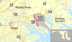
Maryland Route 587 (MD 587) is a state highway in the U.S. state of Maryland. Known as Wilson Point Road, the state highway runs 1.14 miles (1.83 km) from Dogwood Drive north to MD 150 within Middle River in southeastern Baltimore County. MD 587 provides access to Martin State Airport. The state highway was constructed in the mid-1930s from MD 150 to Wilson Point. MD 587's southern terminus was moved to its present spot in the mid-1980s.
Route description
MD 587 begins at the intersection of Wilson Point Road and Dogwood Drive. Wilson Point Road continues south as a two-lane county highway through a residential neighborhood toward the namesake promontory at the confluence of Stansbury Creek on the east and Middle River on the west. MD 587 heads north as a four-lane divided highway between Martin State Airport on the east and apartment complexes on the west. After passing the main entrance to Martin State Airport, the west side of the state highway is lined by Lockheed Martin's Middle River Complex. MD 587 reaches its northern terminus at an intersection with MD 150 (Eastern Boulevard) just south of the Amtrak Northeast Corridor.[1][2]
History
MD 587 was constructed as a macadam road along what was originally Bull Neck Road from MD 150 to Wilson Point in 1934.[3][4] The state highway was widened with a pair of 2-foot (0.61 m) wide concrete shoulders around 1940.[5] MD 587's intersection with MD 150 was rebuilt as a directional crossover intersection when MD 150 was expanded to a four-lane divided highway through Middle River in 1944.[6] The intersection was converted to a standard three-way intersection when MD 587 was expanded to a four-lane divided highway along its present length in 1964.[7] The state highway's southern terminus was moved north to Dogwood Drive around 1987.[8]
Junction list
The entire route is in Middle River, Baltimore County.
| mi[1] | km | Destinations | Notes | ||
|---|---|---|---|---|---|
| 0.00 | 0.00 | Wilson Point Road south / Dogwood Drive west | Southern terminus | ||
| 1.14 | 1.83 | Northern terminus | |||
| 1.000 mi = 1.609 km; 1.000 km = 0.621 mi | |||||
See also
 Maryland Roads portal
References
- 1 2 3 Highway Information Services Division (December 31, 2013). Highway Location Reference. Maryland State Highway Administration. Retrieved 2011-05-17.
- Baltimore County (PDF)
- ↑ Google (2010-08-02). "Maryland Route 587" (Map). Google Maps. Google. Retrieved 2010-08-02.
- ↑ Byron, William D.; Lacy, Robert (December 28, 1934). Report of the State Roads Commission of Maryland (1931–1934 ed.). Baltimore: Maryland State Roads Commission. p. 321. Retrieved 2011-05-14.
- ↑ Maryland State Roads Commission (1934). Map of Maryland Showing State Road System (Map). Baltimore: Maryland State Roads Commission.
- ↑ Whitman, Ezra B.; Webb, P. Watson; Thomas, W. Frank (March 15, 1941). Report of the State Roads Commission of Maryland (1939–1940 ed.). Baltimore: Maryland State Roads Commission. p. 65. Retrieved 2011-05-14.
- ↑ Whitman, Ezra B.; Webb, P. Watson; Thomas, W. Frank (March 1, 1945). Report of the State Roads Commission of Maryland (1943–1944 ed.). Baltimore: Maryland State Roads Commission. p. 38. Retrieved 2011-05-14.
- ↑ Maryland State Roads Commission (1964). Maryland: Official Highway Map (Map). Baltimore: Maryland State Roads Commission.
- ↑ Maryland State Highway Administration (1987). Maryland: Official Highway Map (Map). Baltimore: Maryland State Highway Administration.
