Massachusetts Route 139
| ||||
|---|---|---|---|---|
|
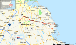
Map of southeastern Massachusetts with Route 139 highlighted in red | ||||
| Route information | ||||
| Maintained by MassDOT | ||||
| Length: | 32.24 mi[1] (51.89 km) | |||
| Major junctions | ||||
| West end: |
| |||
| East end: |
| |||
| Location | ||||
| Counties: | Norfolk, Plymouth | |||
| Highway system | ||||
| ||||

Route 139 is nominally a west–east state highway in southeastern Massachusetts.
Route description
Route 139 begins in Stoughton Square at the southern junction of the Route 27 and 138 concurrency. The highway heads northeast until the junction with Route 24, at which point the highway heads almost due east. After the brief concurrency with Route 28 in Randolph, the highway heads in a generally east-southeasterly direction through Holbrook, the extreme southwest corner of Weymouth, the North Abington section of Abington, Rockland, Hanover, the northern edge of Pembroke, and Marshfield.
Once the highway reaches the shoreline in Marshfield, it turns in a south-southeasterly direction, passing through Fieldston, Ocean Bluff and Brant Rock, proceeding until just north of Brant Rock's esplanade. But then the highway heads west, while still signed east, for the last 4.5 miles (7.2 km), passing through Green Harbor before ending at Route 14 in Duxbury.
Major intersections
| County | Location | mi | km | Destinations | Notes |
|---|---|---|---|---|---|
| Norfolk | Stoughton | 0.00 | 0.00 | Western terminus of Route 139; westbound traffic on Route 139 defaults onto Route 27/138 north | |
| 3.0 | 4.8 | Exit 20 on Route 24 | |||
| Randolph | 4.5 | 7.2 | Western end of Route 28 concurrency | ||
| 4.7 | 7.6 | Eastern end of Route 28 concurrency | |||
| Holbrook | 6.6 | 10.6 | |||
| Plymouth | Abington | 10.3 | 16.6 | ||
| 10.6 | 17.1 | ||||
| Rockland | 12.2 | 19.6 | Western end of Route 123 concurrency | ||
| 12.8 | 20.6 | Eastern end of Route 123 concurrency | |||
| Hanover | 17.9 | 28.8 | Northern terminus of Route 53 concurrency | ||
| Pembroke | 19.0 | 30.6 | Southern terminus of Route 53 concurrency | ||
| 21.0 | 33.8 | Exit 12 on Route 3 | |||
| Marshfield | 23.7 | 38.1 | Western terminus of Route 3A concurrency | ||
| 24.2 | 38.9 | Eastern terminus of Route 3A concurrency | |||
| Duxbury | 31.7 | 51.0 | |||
| 32.24 | 51.89 | "Eastern" terminus of Route 139; eastbound traffic defaults onto Route 14 west | |||
| 1.000 mi = 1.609 km; 1.000 km = 0.621 mi | |||||
References
External links
| Wikimedia Commons has media related to Massachusetts Route 139. |
