Matías Romero, Oaxaca
| Matías Romero | |
|---|---|
| Municipality and town | |
|
Matías Romero Location in Mexico | |
| Coordinates: 16°52′N 95°02′W / 16.867°N 95.033°WCoordinates: 16°52′N 95°02′W / 16.867°N 95.033°W | |
| Country |
|
| State | Oaxaca |
| Area | |
| • Total | 1,459.54 km2 (563.53 sq mi) |
| Population (2005) | |
| • Total | 38,421 |
| Time zone | Central Standard Time (UTC-6) |
| • Summer (DST) | Central Daylight Time (UTC-5) |
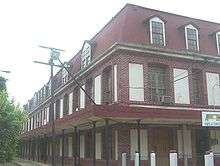
Railway Station, the landmark of Matias Romero
Matías Romero is a town and municipality in Oaxaca in south-western Mexico. The municipality covers an area of 1,459.54 km². It is part of the Juchitán District in the west of the Istmo de Tehuantepec region. El Rio Corte in Colonia Cuauhtemoc is a popular tourist spot, wide and with excellent beaches.[1]
As of 2005, the municipality had a total population of 38,421.[2]
References
- ↑ Página oficial de Matías Romero
- ↑ "Matías Romero". Enciclopedia de los Municipios de México. Instituto Nacional para el Federalismo y el Desarrollo Municipal. Retrieved June 12, 2009.
This article is issued from Wikipedia - version of the 9/24/2014. The text is available under the Creative Commons Attribution/Share Alike but additional terms may apply for the media files.