Millwood, Virginia
| Millwood, Virginia | |
|---|---|
| Unincorporated community | |
|
The Burwell-Morgan Mill in September 2005[2] | |
 Millwood  Millwood  Millwood Location within the state of Virginia | |
| Coordinates: 39°4′10″N 78°2′16″W / 39.06944°N 78.03778°WCoordinates: 39°4′10″N 78°2′16″W / 39.06944°N 78.03778°W | |
| Country |
|
| State |
|
| County |
|
| Time zone | Eastern (EST) (UTC-5) |
| • Summer (DST) | EDT (UTC-4) |
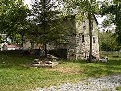
Millwood is an unincorporated community located in Clarke County, Virginia. Millwood is the home of many of Clarke County's most historic sites including the Burwell-Morgan Mill (1785), Carter Hall (1792), the Greenway Historic District, Long Branch (1811), Old Chapel (1790), and the River House. Project HOPE is based at Carter Hall.
History

Carter Hall[3]
Listed on the National Register of Historic Places.[4]
- Burwell-Morgan Mill
- Carter Hall
- Long Branch Plantation
- Millwood Commercial Historic District
- Old Chapel
- River House
References
- ↑ Burwell-Morgan Mill (1785) (Google Earth place mark)
- ↑ Burwell-Morgan Mill (1785) (Google Earth place mark)
- ↑ Carter Hall (1792) (Google Earth place mark)
- ↑ National Park Service (2010-07-09). "National Register Information System". National Register of Historic Places. National Park Service.
External links
- Small Towns of Virginia Series: Millwood
- Carter Hall Conference Center
- Long Branch Farm
- Historic Millwood Photographs
Municipalities and communities of Clarke County, Virginia, United States | ||
|---|---|---|
| Towns | 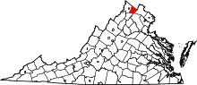 | |
| CDPs | ||
| Unincorporated communities | ||
| Footnotes | ‡This populated place also has portions in an adjacent county or counties | |
This article is issued from Wikipedia - version of the 9/6/2016. The text is available under the Creative Commons Attribution/Share Alike but additional terms may apply for the media files.