Mississippi Highway 15
| ||||
|---|---|---|---|---|
| Route information | ||||
| Maintained by MDOT | ||||
| Length: | 323.949 mi[1] (521.345 km) | |||
| Major junctions | ||||
| South end: |
| |||
|
| ||||
| North end: |
| |||
| Location | ||||
| Counties: | Harrison, Stone, Perry, Jones, Jasper, Newton, Neshoba, Winston, Choctaw, Webster, Oktibbeha, Chickasaw, Pontotoc, Union, Tippah | |||
| Highway system | ||||
| ||||

Mississippi Highway 15 (MS 15) is a state highway in Mississippi. At over 328 miles (528 km), it is the longest highway in the Mississippi Highway System. It begins at a junction with U.S. Route 90 in Biloxi and runs northward to the Mississippi/Tennessee state line near Walnut. It serves a total of 15 counties (Harrison, Stone, Perry, Jones, Jasper, Newton, Neshoba, Winston, Choctaw, Webster, Oktibbeha, Chickasaw, Pontotoc, Union, and Tippah). MS 15 is divided into two sections due to a large gap between Stone County and Perry County. The southern section ends at a junction with MS 26, and the northern section begins at a junction with US 98 in Perry County.
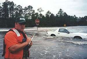
Water flowing over Old Hwy 67 and Mississippi Highway 15 near their intersection in Harrison County on September 29, 1998 during the September 1998 flooding caused on the Tchoutacabouffa River by Hurricane Georges.
Major intersections
| County | Location | mi | km | Destinations | Notes | ||
|---|---|---|---|---|---|---|---|
| Harrison | D'Iberville | I-10 exits 46A-B; south end of MS 67 overlap; signed as exits 4A (east) and 4B (west); cloverleaf interchange. | |||||
| Sangani Boulevard / Promenade Parkway | interchange | ||||||
| | interchange; north end of MS 67 overlap | ||||||
| Stone | Moore Crossing | ||||||
| Gap in route | |||||||
| Perry | | interchange; south end of MS 198 overlap | |||||
| Beaumont | north end of MS 198 overlap | ||||||
| Richton | south end of MS 42 overlap | ||||||
| north end of MS 42 overlap | |||||||
| | George Boutwell Road (MS 536) | ||||||
| Jones | Laurel | south end of I-59 / US 84 overlap; MS 15 south follows exit 96B | |||||
| 4th Avenue / Masonite Road | I-59 exit 96A | ||||||
| Beacon Street | I-59 exit 95C | ||||||
| north end of I-59 overlap; MS 15 north follows exit 95B | |||||||
| north end of US 84 overlap | |||||||
| | |||||||
| Jasper | | ||||||
| Bay Springs | |||||||
| Newton | | ||||||
| Newton | |||||||
| I-20 exit 109 | |||||||
| Decatur | |||||||
| Union | |||||||
| Neshoba | Good Hope | ||||||
| Philadelphia | south end of MS 21 overlap | ||||||
| south end of MS 16 overlap | |||||||
| Cooper Williams Drive - Williamsville | |||||||
| north end of MS 16 / MS 21 overlap; south end of MS 19 overlap | |||||||
| interchange; north end of MS 19 overlap | |||||||
| Winston | Noxapater | ||||||
| Louisville | interchange; south end of MS 25 overlap | ||||||
| | interchange; north end of MS 25 overlap | ||||||
| Choctaw | | FR 967 (Choctaw Lake Road) – Choctaw Lake Wildlife Management | proposed MS 768 | ||||
| Ackerman | Ackerman (MS 759) | ||||||
| Williams | |||||||
| Webster | Mathiston | south end of US 82 overlap | |||||
| | interchange; north end of US 82 overlap | ||||||
| | south end of MS 50 overlap | ||||||
| | north end of MS 50 overlap | ||||||
| | Natchez Trace | interchange | |||||
| Mantee | |||||||
| Chickasaw | Woodland | ||||||
| Houston | interchange | ||||||
| | south end of MS 32 overlap | ||||||
| Old Houlka | north end of MS 32 overlap | ||||||
| Pontotoc | Algoma | ||||||
| Pontotoc | |||||||
| interchange | |||||||
| Ecru | |||||||
| Union | | ||||||
| New Albany | interchange; south end of MS 30 overlap; I-22 exit 64 | ||||||
| north end of MS 30 overlap | |||||||
| Tippah | Blue Mountain | ||||||
| Ripley | south end of MS 4 overlap | ||||||
| north end of MS 4 overlap | |||||||
| | |||||||
| | proposed MS 369 | ||||||
| | Main Street | proposed MS 777 | |||||
| Walnut | |||||||
| | Tennessee state line | ||||||
1.000 mi = 1.609 km; 1.000 km = 0.621 mi
| |||||||
References
- ↑ "Mississippi Public Roads Selected Statistics" (PDF). Mississippi Department of Transportation. 2008. Retrieved 2010-06-03.
This article is issued from Wikipedia - version of the 10/21/2016. The text is available under the Creative Commons Attribution/Share Alike but additional terms may apply for the media files.