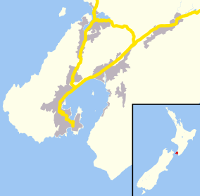
Mount Cook, Wellington
| Mount Cook | |
|---|---|
 Mount Cook | |
| Basic information | |
| Local authority | Wellington City |
| Coordinates | 41°18′06″S 174°46′27″E / 41.301764°S 174.774031°ECoordinates: 41°18′06″S 174°46′27″E / 41.301764°S 174.774031°E |
| Population | 5,112[1] (2013) |
| Surrounds | |
| North | Te Aro |
| Northeast | Mount Victoria |
| East | Hataitai |
| South | Newtown |
| Southwest | Brooklyn |
| Northwest | Aro Valley |
The suburb of Mount Cook in Wellington in New Zealand stands on the southern fringe of the central city alongside Te Aro and to the north of Newtown. At the time of the 2013 census it had a population of 5,112, an increase of 261 people since 2006.[1]
The suburb contains a small hill named Mount Cook, the origin-point of the original survey marks through Wellington. The hill took its name from Captain James Cook.
Mount Cook's institutions include the Colonial Cottage Museum, the Wellington campus of Massey University and the National War Memorial.
Education
- Wellington High School and Community Education Centre is a state co-educational secondary (years 9-15) school. It has a decile rating of 9 and a roll of 998. [2]
- Mount Cook School is a state co-educational full (years 1-8) primary school. It has a decile rating of 5 and a roll of 177. [3]
Universities
Mount Cook has one university Massey University Wellington Campus with the main campus being in Palmerston North and with other campuses being in Auckland and in Christchurch
References
External links
This article is issued from Wikipedia - version of the 11/28/2016. The text is available under the Creative Commons Attribution/Share Alike but additional terms may apply for the media files.