Mount Ogura
| Mount Ogura | |
|---|---|
| 御座山 | |
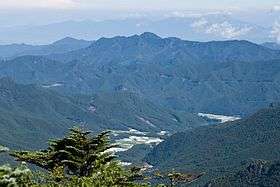 A view from Mt. Kitaokusenjo | |
| Highest point | |
| Elevation | 2,112 m (6,929 ft) |
| Coordinates | 36°2′2.7″N 138°36′24.5″E / 36.034083°N 138.606806°ECoordinates: 36°2′2.7″N 138°36′24.5″E / 36.034083°N 138.606806°E |
| Naming | |
| Translation | mountain on which a god stays (Japanese) |
| Geography | |
 Mount Ogura Location in Japan | |
| Location | Nagano, Japan |
| Parent range | Chichibu Mountains |
Mount Ogura (御座山 Ogura-san) is a mountain located between Kitaaiki and Minamiaiki Villages, Minamisaku District, Nagano Prefecture, Japan. With its summit being 2,112 meters above sea level, it is the tallest mountain in Minamiaiki, Nagano.
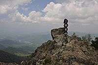
Mount Ogura at Its Summit
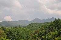
Mount Ogura as Seen from Kitaaiki Village, Nagano Prefecture.
It is known for the Japanese rhododendron flowers (shakunage in Japanese) that come into full bloom in early to mid-June.
External links
- From the official site of Minamiaiki Village (in Japanese)
This article is issued from Wikipedia - version of the 11/12/2016. The text is available under the Creative Commons Attribution/Share Alike but additional terms may apply for the media files.
