Mouzieys-Panens
| Mouzieys-Panens | |
|---|---|
|
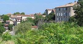
A general view of Mouzieys | |
 Mouzieys-Panens | |
|
Location within Occitanie region  Mouzieys-Panens | |
| Coordinates: 44°05′36″N 1°56′00″E / 44.0933°N 1.9333°ECoordinates: 44°05′36″N 1°56′00″E / 44.0933°N 1.9333°E | |
| Country | France |
| Region | Occitanie |
| Department | Tarn |
| Arrondissement | Albi |
| Canton | Cordes-sur-Ciel |
| Intercommunality | Pays Cordais |
| Government | |
| • Mayor (2008–2014) | Claude Blanc |
| Area1 | 13.13 km2 (5.07 sq mi) |
| Population (2006)2 | 213 |
| • Density | 16/km2 (42/sq mi) |
| Time zone | CET (UTC+1) |
| • Summer (DST) | CEST (UTC+2) |
| INSEE/Postal code | 81191 / 81170 |
| Elevation |
150–328 m (492–1,076 ft) (avg. 260 m or 850 ft) |
|
1 French Land Register data, which excludes lakes, ponds, glaciers > 1 km² (0.386 sq mi or 247 acres) and river estuaries. 2 Population without double counting: residents of multiple communes (e.g., students and military personnel) only counted once. | |
Mouzieys-Panens is a commune in the Tarn department in southern France.
Geography
The commune is traversed by the Cérou river.
Monuments
The village is dominated by a castle that was built in the 12th century by Guillaume de Cadolhe. It was later fortified during the Hundred Years' War. It served as an outlook post for Cordes-sur-Ciel. In 1566, the castle came into possession of Count Bernard de Rabastens. It was the scene of battles and was set to fire. In the 18th century the castle was rebuilt and, now demilitarised, it serves as mairie.
Saint Michael's Church at the bottom of the village is a classified monument.
See also
References
| Wikimedia Commons has media related to Mouzieys-Panens. |
This article is issued from Wikipedia - version of the 3/17/2015. The text is available under the Creative Commons Attribution/Share Alike but additional terms may apply for the media files.
