Mshana, Horodok Raion
| Mshana Мшана | |
|---|---|
| village | |
 Mshana | |
| Coordinates: UA 49°49′44″N 23°47′14″E / 49.82889°N 23.78722°ECoordinates: UA 49°49′44″N 23°47′14″E / 49.82889°N 23.78722°E | |
| Country |
|
| Province |
|
| District |
|
| Established | 1453 |
| Area | |
| • Total | 14,33 km2 (553 sq mi) |
| Elevation/(average value of) | 293 m (961 ft) |
| Population | |
| • Total | 2,821 |
| • Density | 196,86/km2 (50,990/sq mi) |
| Time zone | EET (UTC+2) |
| • Summer (DST) | EEST (UTC+3) |
| Postal code | 81512 |
| Area code | +380 3231 |
| Website | село Мшана (Ukrainian) |
Mshana (Ukrainian: Мша́на) is a village (selo) in the Lviv Oblast (province) of western Ukraine. It is located in the Horodok district (Horodok Raion).
The population of the village is about 2821 people and local government is administered by Mshanska village council.[1]
Geography
The village is situated at an altitude of 293 metres (960 ft) above sea level.
Through the village passes railway from Lviv to Przemyśl in Poland and is located at a distance of 4 kilometres (2.5 mi) from the highway in Ukraine ![]() connecting Lviv with Przemyśl. Distance from the district center of Horodok is 15 kilometres (9.3 mi), 20 kilometres (12 mi) from the regional center of Lviv and 81 kilometres (50 mi) to the Przemyśl.
connecting Lviv with Przemyśl. Distance from the district center of Horodok is 15 kilometres (9.3 mi), 20 kilometres (12 mi) from the regional center of Lviv and 81 kilometres (50 mi) to the Przemyśl.
History and Attractions
The first record of the village dates back to 1453 year.[2] The origin of the name of the village probably derives from Polish words 'msha' (of God liturgy).[3]
The village has an architectural monument of local importance of Horodok Raion (Horodok district) – Introduction of the Blessed Virgin Mary Church (wooden, 1799) (1574 –м).[4]
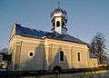 Church Introduction of the Blessed Virgin Mary
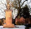 Monument of Ivan Franko in the village Mshana
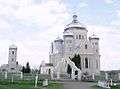 Church of the Presentation of the Blessed Virgin Mary UOC-KP
References
External links
Literature
- Ukrainian: (Історія міст і сіл УРСР : Львівська область. – К. : ГРУРЕ, 1968 р.) Page 260
| Cities | ||
|---|---|---|
| Urban-type settlements |
| |
| Villages |
| |