Naalehu, Hawaii
| Naalehu, Hawaii Naʻālehu | |
|---|---|
| CDP | |
|
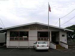
Naalehu Post Office | |
 Location in Hawaii County and the state of Hawaii | |
| Coordinates: 19°3′57″N 155°35′15″W / 19.06583°N 155.58750°WCoordinates: 19°3′57″N 155°35′15″W / 19.06583°N 155.58750°W | |
| Country | United States |
| State | Hawaii |
| County | Hawaii |
| Area | |
| • Total | 2.2 sq mi (5.6 km2) |
| • Land | 2.2 sq mi (5.6 km2) |
| • Water | 0.0 sq mi (0.0 km2) |
| Elevation | 738 ft (225 m) |
| Population (2010) | |
| • Total | 866 |
| • Density | 393.6/sq mi (154.6/km2) |
| Time zone | Hawaii-Aleutian (UTC-10) |
| ZIP code | 96772 |
| Area code(s) | 808 |
| FIPS code | 15-53600 |
| GNIS feature ID | 0362519 |
Naalehu (Naʻālehu means "the volcanic ashes" in Hawaiian[1]) is a census-designated place in Hawaii County, Hawaii. The population was 919 at the 2000 census. It is the southernmost town in the 50 states of the United States. (See Extreme Points.)
Geography
Naalehu is located at 19°3′57″N 155°35′15″W / 19.06583°N 155.58750°W (19.065925, -155.587528)[2] in the Kaʻū District.
According to the United States Census Bureau, the CDP has a total area of 2.2 square miles (5.7 km2), all of it land.
Demographics
As of the census[3] of 2000, there were 919 people, 290 households, and 209 families residing in the CDP. The population density was 426.1 people per square mile (164.3/km²). There were 332 housing units at an average density of 153.9 per square mile (59.3/km²). The racial makeup of the CDP was 8.38% White, 0.33% African American, 0.11% Native American, 45.59% Asian, 13.82% Pacific Islander, 0.33% from other races, and 31.45% from two or more races. Hispanic or Latino of any race were 5.44% of the population.
There are 290 households out of which 31.7% have children under the age of 18 living with them, 54.1% were married couples living together, 11.0% had a female householder with no husband present, and 27.9% were non-families. 25.9% of all households were made up of individuals and 12.1% had someone living alone who was 65 years of age or older. The average household size was 3.17 and the average family size was 3.77.
In the CDP the population was spread out with 30.6% under the age of 18, 7.7% from 18 to 24, 23.4% from 25 to 44, 21.8% from 45 to 64, and 16.5% who were 65 years of age or older. The median age was 36 years. For every 100 females there were 96.8 males. For every 100 females age 18 and over, there were 96.3 males.
The median income for a household in the CDP was $31,750, and the median income for a family was $36,964. Males had a median income of $23,625 versus $20,125 for females. The per capita income for the CDP was $11,755. 20.4% of the population and 16.8% of families were below the poverty line. Out of the total population, 22.0% of those under the age of 18 and 6.6% of those 65 and older were living below the poverty line.
Points of interest
Naalehu is home to one of several ground communication stations operated by Bigelow Aerospace [4] that is used to communicate with its space modules in orbit. Southern most church in the United States: Lighthouse Baptist Church
Climate
| Climate data for Naalehu 14, HI, 1981-2010 normals, extremes 1905-present | |||||||||||||
|---|---|---|---|---|---|---|---|---|---|---|---|---|---|
| Month | Jan | Feb | Mar | Apr | May | Jun | Jul | Aug | Sep | Oct | Nov | Dec | Year |
| Record high °F (°C) | 89 (32) |
92 (33) |
93 (34) |
89 (32) |
93 (34) |
92 (33) |
96 (36) |
96 (36) |
92 (33) |
90 (32) |
90 (32) |
91 (33) |
96 (36) |
| Average high °F (°C) | 77.6 (25.3) |
78.1 (25.6) |
78.0 (25.6) |
78.1 (25.6) |
79.1 (26.2) |
80.0 (26.7) |
80.7 (27.1) |
81.5 (27.5) |
82.1 (27.8) |
81.2 (27.3) |
79.6 (26.4) |
77.9 (25.5) |
79.5 (26.4) |
| Average low °F (°C) | 62.6 (17) |
62.2 (16.8) |
63.2 (17.3) |
64.2 (17.9) |
65.3 (18.5) |
66.8 (19.3) |
67.3 (19.6) |
68.1 (20.1) |
67.9 (19.9) |
67.4 (19.7) |
66.2 (19) |
64.5 (18.1) |
65.5 (18.6) |
| Record low °F (°C) | 50 (10) |
52 (11) |
50 (10) |
50 (10) |
50 (10) |
54 (12) |
53 (12) |
60 (16) |
56 (13) |
59 (15) |
55 (13) |
54 (12) |
50 (10) |
| Average precipitation inches (mm) | 5.37 (136.4) |
4.09 (103.9) |
4.11 (104.4) |
3.19 (81) |
2.38 (60.5) |
1.87 (47.5) |
3.57 (90.7) |
3.28 (83.3) |
4.04 (102.6) |
4.67 (118.6) |
6.53 (165.9) |
5.64 (143.3) |
48.74 (1,238.1) |
| Average rainy days (≥ 0.01 in) | 9.8 | 7.9 | 8.5 | 11.3 | 12.2 | 8.4 | 10.1 | 10.4 | 11.9 | 12.9 | 10.9 | 10.8 | 125.1 |
| Source: | |||||||||||||
Gallery
 South Point Wind Farm
 Shaka restaurant in Naalehu advertises itself as “The Most Southern Bar in U.S.A.”
References
- ↑ Pukui, Mary Kawena. Place Names of Hawaii. University of Hawaii Press. ISBN 0-8248-0524-0.
- ↑ "US Gazetteer files: 2010, 2000, and 1990". United States Census Bureau. 2011-02-12. Retrieved 2011-04-23.
- ↑ "American FactFinder". United States Census Bureau. Retrieved 2008-01-31.
- ↑ Bigelow Aerospace: Commercial Spacecraft and Complexes - Space Business

