Nadole, Žetale
| Nadole | |
|---|---|
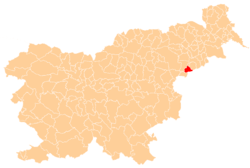
 Nadole Location in Slovenia | |
| Coordinates: 46°17′10.29″N 15°45′34.08″E / 46.2861917°N 15.7594667°ECoordinates: 46°17′10.29″N 15°45′34.08″E / 46.2861917°N 15.7594667°E | |
| Country |
|
| Traditional region | Styria |
| Statistical region | Drava |
| Municipality | Žetale |
| Area | |
| • Total | 4.31 km2 (1.66 sq mi) |
| Elevation | 361 m (1,184 ft) |
| Population (2002) | |
| • Total | 152 |
| [1] | |
Nadole (pronounced [ˈnaːdɔlɛ]) is a settlement in the Municipality of Žetale in eastern Slovenia. It lies in the Haloze Hills and is made up of a number of smaller dispersed hamlets: Jesenice, Kofirt, Ložec, Marija Vas (Slovene: Marija vas), Menik, Nadola, Pušjek, Rodni Dol, Sep, Strmec, Topole, Tomanje, Višnjavec, Zagaj, Zalopata, and Zlaka. The area traditionally belonged to the Styria region. It is now included in the Drava Statistical Region.[2]
References
External links
| Settlements | Administrative centre: Žetale
|  | ||||||
|---|---|---|---|---|---|---|---|---|
| Landmarks |
| |||||||
This article is issued from Wikipedia - version of the 11/20/2016. The text is available under the Creative Commons Attribution/Share Alike but additional terms may apply for the media files.
