Naranjito, Puerto Rico
| Naranjito, Puerto Rico | ||
|---|---|---|
| Municipality | ||
| ||
| Nickname(s): "La Ciudad de los Colores", "El Pueblo de los Changos", "La Cuna del Voleibol" | ||
| Motto: "Naranjito Brilla" | ||
| Anthem: Naranjito, mi hogar predilecto | ||
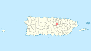
 Location of Naranjito in Puerto Rico | ||
| Coordinates: 18°18′03″N 66°14′42″W / 18.30083°N 66.24500°WCoordinates: 18°18′03″N 66°14′42″W / 18.30083°N 66.24500°W | ||
| Country |
| |
| Territory |
| |
| Founded | December 3, 1824 | |
| Founded by | Braulio Morales | |
| Government | ||
| • Mayor | Hon. Orlando Ortíz Chevres (PNP) | |
| • Senatorial District |
VI - Guayama Carlos J. Torres Torres (PNP) | |
| • Representative District |
28 Rafael Rivera Ortega (PNP) | |
| Area | ||
| • Total | 28.4 sq mi (73.54 km2) | |
| • Land | 28.2 sq mi (73.0 km2) | |
| • Water | 0.2 sq mi (0.54 km2) | |
| Elevation | 2,997 ft (700 m) | |
| Population (2010) | ||
| • Total | 30,402 | |
| • Density | 1,100/sq mi (410/km2) | |
| Demonym(s) | Naranjiteños | |
| Time zone | AST (UTC-4) | |
| Zip code | 00719 | |
| Area code | +1 (spec. +1-787 and +1-939) | |
Naranjito (Spanish pronunciation: [naɾaŋˈxito], Little Orange) is a municipality of Puerto Rico located in the central region of the island, south of Toa Alta; north of Barranquitas and Comerío; east of Corozal; and west of Bayamón. Naranjito is spread over 15 wards and Naranjito Pueblo (The downtown area and the administrative center of the city). It is part of the San Juan-Caguas-Guaynabo Metropolitan Statistical Area.
History
The struggle to form the Naranjito town began in 1810. After a series of major incidents with powerful political interests of the time, on December 3, 1824, Don Braulio Morales successfully founded the town of Naranjito. The town was founded in the neighborhood of the same name, on a land donated by Doña Manuela Rivera and Don Braulio Morales. Morales was named "Captain Settler" and at the same time was appointed mayor of the town in development. The name "Naranjito" is derived from a small orange tree that served as a reference point for travelers looking for in the shortest way to the town of Toa Alta. At the time of its foundation, Naranjito consisted of five wards/districts, "Lomas", "Guadiana", "Achiote", "Nuevo" and "Cedro". "Cedro" was divided in 1853 in "Cedro Arriba" and "Cedro Abajo", also having the urban zone composed by "San Miguel", "San Antonio" and "San Cristobal" districts.[1]
Cityscape
Barrios
Tourism
Landmarks and places of interest
- Anones Park
- Cancha Gelito Ortega
- Cedro Abajo Falls (Las Lagrimas Falls)
- La Marina Boardwalk
- La Plata Lake
- Las Avispas Hills
- Municipal Swimming Pool
- Trovador Plaza
- Mirador de Anones
- Puente Atirantado Jesús Izcoa Moure
- El Cerro Community
Economy
Traditionally the main agricultural crops of Naranjito are coffee and the tobacco. In recent years have borne fruits such as bananas, oranges, papayas, and other tropical fruits; also in the town the poultry factory has been very popular, specifically the dairy cattle (fresh milk). Naranjito has many factories, most of these factories make garments (clothing).[3]
Culture
Festivals and events
- Mothers Day - May
- San Antonio Day - June
- Chango Festival - June
- Anon Festival - June
- Volleyball Tournament - February - June
- San Miguel Arcangel Day - September
- Patron Festivities - September - October
- Turkey marathon - November
Sports
"Los Changos de Naranjito" are a professional male volleyball team based in Naranjito. The team is one of the most successful sport's franchises in Puerto Rico.[4]
Government
All municipalities in Puerto Rico are administered by a mayor, elected every four years. On November 4, 2008, Orlando Ortíz Chevres (of the New Progressive Party), won the elections.
The city belongs to the Puerto Rico Senatorial district VI, which is represented by two Senators. In 2012, Miguel Pereira Castillo and Angel M. Rodríguez were elected as District Senators.[5]
Symbols
Flag
Naranjito's flag consists of an orange flag crossed by two narrow green stripes close to the superior and inferior edges. The orange color in the flag symbolizes the town of Naranjito (little orange tree), while the green symbolizes its green mountains.
Coat of arms
The coat of arms is a red cross, the symbol of San Miguel de Arcángel, Patron of Naranjito. The globe with the cross symbolizes the power and sovereignty of God. The gold and red stripes that appear in the second and third quarters, constitute the primitive baton of the Guadiana lineage. The lily twigs are a tribute of San Antonio de Padua, confessor and doctor of the Church. The orange tree represents the small tree that gave the town's name, Naranjito. The crown is symbol of moral unit of the town.
Education
Naranjito includes several public and private schools distributed through several regions. Public education is handled by the Puerto Rico Department of Education
Elementary schools
- Bernarda Robles De Hevia
- Don Manolo Rivera
- Felipa Sanchez Cruzado
- Jose Archilla Cabrera
- Lomas Valles
- Francisco Roque Muñoz
- Rosa Luz Zayas
- Silvestre Martinez
Middle and junior high schools
- Coleen Vazquez Urrutia
- Mercedes Rosado
- S.U. Adolfo Garcia
- S.U. Fidel G Padilla
- S.U. Pedro Fernandez
High schools
- Francisco Morales
- Vocacional Rubén Rodríguez Figueroa
Private schools
- Academia Santa Teresita (K-12)
Books about Naranjito
- El Chango. Apuntes Historicos del Pueblo de Naranjito-1824-1998, Author: Silvestre J. Morales 1999
See also
- List of Puerto Ricans
- History of Puerto Rico
- Did you know-Puerto Rico?
References
External links
- Morales, Papucho (2009). Manual informativo del Gobierno Municipal de Naranjito, Puerto Rico. Gobierno Municipal de Naranjito, PR.
