Nashville, Missouri
| Nashville, Missouri | |
|---|---|
| unincorporated community | |

| |
| Coordinates: 37°24′28″N 94°27′34″W / 37.40778°N 94.45944°W | |
| Country | United States |
| State | Missouri |
| County | Barton |
| Area | |
| • Total | 48.6 sq mi (125.9 km2) |
| • Land | 48.5 sq mi (125.6 km2) |
| • Water | 0.1 sq mi (0.3 km2) |
| Elevation | 958 ft (292 m) |
| Population (2000) | |
| • Total | 396 |
| • Density | 8.2/sq mi (3.2/km2) |
| Time zone | Central (CST) (UTC-6) |
| • Summer (DST) | CDT (UTC-5) |
| FIPS code | 29-51248[1] |
| GNIS feature ID | 0766282[2] |
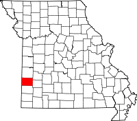
Nashville is a small unincorporated community in southwestern Barton County, Missouri. It is located one mile west of Route 43 about twelve miles southwest of Lamar.
Nashville was platted in 1869.[3] The name is a transfer from Nashville, Tennessee.[3] A post office called Nashville was established in 1861, and remained in operation until 1959.[4]
Harlow Shapley, an astronomer, was born at Nashville in 1885.[5]
References
- ↑ "American FactFinder". United States Census Bureau. Retrieved 2008-01-31.
- ↑ "US Board on Geographic Names". United States Geological Survey. 2007-10-25. Retrieved 2008-01-31.
- 1 2 "Barton County Place Names, 1928-1945 (archived)". The State Historical Society of Missouri. Retrieved 31 August 2016.
- ↑ "Post Offices". Jim Forte Postal History. Retrieved 27 August 2016.
- ↑ Kuehn, Kerry (15 September 2014). A Student's Guide Through the Great Physics Texts: Volume I: The Heavens and The Earth. Springer. p. 273. ISBN 978-1-4939-1360-2.
Coordinates: 37°22′28″N 94°29′27″W / 37.37444°N 94.49083°W
This article is issued from Wikipedia - version of the 11/17/2016. The text is available under the Creative Commons Attribution/Share Alike but additional terms may apply for the media files.
