North Carolina Highway 96
| ||||
|---|---|---|---|---|
|
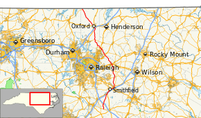
Route of NC 96 in red | ||||
| Route information | ||||
| Maintained by NCDOT | ||||
| Length: | 106.7 mi[1] (171.7 km) | |||
| Existed: | 1940 – present | |||
| Major junctions | ||||
| South end: |
| |||
|
| ||||
| North end: |
| |||
| Location | ||||
| Counties: | Sampson, Johnston, Wake, Franklin, Granville | |||
| Highway system | ||||
| ||||

North Carolina Highway 96 (NC 96) is a primary state highway in the U.S. state of North Carolina. It is a predominantly rural highway that travels north-south; from NC 55, west of Newton Grove, to Virgilina, Virginia, where it continues on as Virginia State Route 96. It also connects the cities of Smithfield, Selma, Zebulon, Youngsville and Oxford.
Route description
History
The current NC 96 was established in 1940 as a renumbering of NC 562; it ran from NC 56, in Wilton, to Virgilina, Virginia.[2] In 1952, NC 96 was extended south as a new primary routing to Youngsville, replaced NC 98 and NC 264 to Zebulon, new primary routing to Selma, concurrency with US 301 to Four Oaks, and finally new primary routing to end at NC 55. Around 1960, NC 96 was adjusted in the Four Oaks area to accomidate I-95; it was placed on concurrency briefly with US 701, leaving behind part of US 301 and Boyette Road (SR-1182).[3]
The first NC 96 existed from 1930-1940; it originally traversed from NC 90, near Taylorsville, south to NC 17, in Hickory.[4] In 1934, it was extended further south to NC 73, in Propst Crossroads, replacing part of NC 17. Between 1931-1936, NC 96 was rerouted at the Catawba River onto a new crossing at Shiloh Church Road.[5] In 1940, the entire route was renumbered to NC 127.
North Carolina Highway 562
| |
|---|---|
| Location: | Wilton, NC–Virgilina, VA |
| Length: | 32.2 mi[6] (51.8 km) |
| Existed: | 1932–1940 |
North Carolina Highway 562 (NC 562) was established as a new primary routing from NC 56, in Wilton, to Virgilina, at the Virginia state line.[5] In 1940, NC 562 was renumbered in favor of NC 96.[2]
Major intersections
| County | Location | mi[1] | km | Destinations | Notes |
|---|---|---|---|---|---|
| Sampson | | 0.0 | 0.0 | ||
| Johnston | Peacocks Crossroads | 4.6 | 7.4 | ||
| | 5.3– 5.4 | 8.5– 8.7 | Exit 334 (I-40) | ||
| Four Oaks | 15.2– 15.6 | 24.5– 25.1 | Exit 90 (I-95); brief concurrency with US 701 at its northern terminus; southern end of US 301 concurrency | ||
| Smithfield | 20.1 | 32.3 | |||
| Selma | 22.6 | 36.4 | Southern end of NC 39 concurrency | ||
| 24.1 | 38.8 | Northern end of US 301 / NC 39 concurrencies | |||
| Jordan | 33.1 | 53.3 | |||
| Hocutts Crossroads | 38.6 | 62.1 | |||
| Wake | Zebulon | 45.2 | 72.7 | Southern end of US 64 Bus. Concurrency | |
| 45.9– 46.1 | 73.9– 74.2 | Exit 435 (US 64); northeren end of US 64 Bus. concurrency; future I-495 | |||
| | 56.1 | 90.3 | |||
| | 57.3 | 92.2 | |||
| Franklin | Youngsville | 62.6 | 100.7 | Southern end of US 1A concurrency | |
| 63.2 | 101.7 | Northern end of US 1A concurrency | |||
| 64.2 | 103.3 | ||||
| Granville | Wilton | 74.1 | 119.3 | ||
| | 85.5– 85.6 | 137.6– 137.8 | Exit 204 (I-85) | ||
| Oxford | 86.7 | 139.5 | Southern end of US 15 concurrency | ||
| 86.9 | 139.9 | Southern end of US 158 Bus. concurrency | |||
| 87.7 | 141.1 | Northern end of US 15 concurrency | |||
| 88.2 | 141.9 | Northern end of US 158 Bus. concurrency | |||
| | 88.6 | 142.6 | |||
| | 106.6 | 171.6 | Southern end of NC 49 concurrency | ||
| | 106.7 | 171.7 | Virginia state line; northern end of NC 49 concurrency | ||
1.000 mi = 1.609 km; 1.000 km = 0.621 mi
| |||||
See also
- U.S. Bicycle Route 1 - Concurrent with NC 96 from Horseshoe Road to Cannady Mill Road in southern Granville County
- North Carolina Bicycle Route 4 - Concurrent with NC 96 from Mountain Creek Road to Goshen Road in northern Granville County
References
- 1 2 Google (May 6, 2015). "North Carolina Highway 96" (Map). Google Maps. Google. Retrieved May 6, 2015.
- 1 2 North Carolina Official Highway Map (PDF) (Map). Cartography by NCDOT. North Carolina Department of Transportation. 1951. Retrieved June 6, 2014.
- ↑ North Carolina Official Highway Map (PDF) (Map). Cartography by NCDOT. North Carolina Department of Transportation. 1960. Retrieved June 6, 2014.
- ↑ State Highway System of North Carolina (PDF) (Map). Cartography by NCDOT. North Carolina Department of Transportation. 1930. Retrieved June 6, 2014.
- 1 2 North Carolina Primary Highway System (PDF) (Map). Cartography by NCDOT. North Carolina Department of Transportation. 1940. Retrieved June 6, 2014.
- ↑ Google (June 6, 2014). "North Carolina Highway 562" (Map). Google Maps. Google. Retrieved June 6, 2014.
External links
-
 Media related to North Carolina Highway 96 at Wikimedia Commons
 - NCRoads.com: N.C. 96
- NCRoads.com: N.C. 562