U.S. Route 301 in North Carolina
| ||||
|---|---|---|---|---|
|
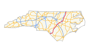
Route of US 301 in North Carolina highlighted in red | ||||
| Route information | ||||
| Auxiliary route of US 1 | ||||
| Maintained by NCDOT | ||||
| Length: | 193.7 mi[1] (311.7 km) | |||
| Existed: | 1932 – present | |||
| Major junctions | ||||
| South end: |
| |||
|
| ||||
| North end: |
| |||
| Location | ||||
| Counties: | Robeson, Cumberland, Harnett, Harnett, Johnston, Wilson, Nash, Edgecombe, Halifax, Northampton | |||
| Highway system | ||||
| ||||

U.S. Route 301 (US 301) is a north–south United States highway that runs for 194 miles (312 km) in North Carolina from the South Carolina state line near Rowland to the Virginia state line near Pleasant Hill.
Route description
US 301 generally follows the same route as Interstate 95 (I-95) through North Carolina; they both enter the state near the South of the Border attraction in South Carolina, overlap together around Lumberton, and share multiple interchanges before reaching Virginia.
Starting at the South Carolina border concurrent with US 501, it goes northwest through Rowland before merging with I-95 from exit 10 to exit 22. North of Lumberton, it crosses I-95 twice before entering Fayetteville, overlapped with I-95 Business along Eastern Boulevard. North of Eastover, it crosses under North Carolina Highway 295 (NC 295), also known as Future I-295, as it parallels I-95 to its immediate west. Traversing through the cities of Wade, Godwin, Dunn, and Benson, where it crosses over I-40 without an interchange; it continues on through Smithfield, Selma, and Micro. At Kenly, US 301 goes away from I-95 into the cities of Wilson and Rocky Mount, before returning to a more easterly parallel to the Interstate. US 301 continues north through the towns of Enfield, Halifax, Weldon, and Garysburg before crossing into Virginia.[1]
History
US 301 was established in 1932, replacing US 217 from the South Carolina state line to Wilson, and US 17-1 from Wilson to the Virginia state line. In 1934, NC 22 and NC 40 were dropped along the route.[2][3]
Route changes along US 301 started in the early-1950s with a new bypass (Eastern Boulevard) around central Fayetteville and a new bypass west of Halifax. In 1955 or 1956, a new bypass (Ward Boulevard) was built east of Wilson. By 1958, US 301 was widen to a four-lane road around Lumberton, Fayetteville, and between Kenly and Rocky Mount; it was also at this time that Elm City was bypassed. In 1961, I-95 was overlapped with US 301 on the Lumberton bypass. By 1984, US 301 was extended south along I-95 to exit 10, keeping its routing through Rowland.[2]
U.S. Route 217
| |
|---|---|
| Location: | SC state line-Wilson, NC |
| Length: | 126.7 mi[4] (203.9 km) |
| Existed: | 1926–1932 |
U.S. Route 217 (US 217) was an original U.S. Highway, established in 1926, and was completely overlapped with NC 22. The original highway continued south into South Carolina to end in Pee Dee. US 217 entered from South Carolina south of Rowland where it went north through Rowland and into Lumberton via Hilly Branch Road and 5th Street. Going north on Pine Street and Fayetteville Road, it connected with Fayetteville where it went north on Gillespie Street, then east on Person Street, before it went north again on Dunn Road. Entering Dunn on Clinton Street, it went west on Cumberland Street (NC 60), then north on Ellis Avenue. It entered Smithfield on 3rd Street, and went east on Market Street then north again on 8th Street. As it approached Wilson from the south, it ended at US 17-1/NC 40 (Dixie Inn Road). In 1932, the entire route was renumbered as part of US 301.
Junction list
| County | Location | mi[1] | km | Exit | Destinations | Notes |
|---|---|---|---|---|---|---|
| Robeson | | 0.0 | 0.0 | South Carolina state line; exits 1A–1B (I-95) | ||
| Rowland | 2.7 | 4.3 | North end of US 501 overlap | |||
| | 11.8 | 19.0 | 10 | South end of I-95 overlap | ||
| Lumberton | 14.5 | 23.3 | 13 | Signed as exits 13A (east) and 13B (west) | ||
| 18.5 | 29.8 | 17 | Southern terminus of NC 711 | |||
| 20.2 | 32.5 | 19 | Carthage Road | |||
| 21.4 | 34.4 | 20 | ||||
| 23.0 | 37.0 | 22 | North end of I-95 overlap | |||
| | 27.0 | 43.5 | Exit 25 (I-95) | |||
| Saint Pauls | 33.2 | 53.4 | ||||
| | 35.5 | 57.1 | Exit 33 (I-95) | |||
| | 40.2 | 64.7 | ||||
| Cumberland | | 43.0 | 69.2 | South end of I-95 Business overlap; interchange; northbound US 301 to northbound BL 95 and southbound BL 95 to southbound US 301 access only | ||
| Hope Mills | 43.6 | 70.2 | Interchange | |||
| 45.6 | 73.4 | Eastern terminus of NC 162 | ||||
| Fayetteville | 50.6 | 81.4 | Exit 102 (NC 87) | |||
| 52.4 | 84.3 | |||||
| 53.8 | 86.6 | Middle Road | Interchange | |||
| | 55.6 | 89.5 | Dobbins Holmes Road | Interchange | ||
| Eastover | 57.3 | 92.2 | North end of I-95 Business overlap; interchange | |||
| 60.2 | 96.9 | |||||
| Godwin | 68.5 | 110.2 | ||||
| Harnett | Dunn | 76.4 | 123.0 | |||
| Johnston | Benson | 83.2 | 133.9 | South end of NC 242 overlap | ||
| 83.7 | 134.7 | North end of NC 242 overlap | ||||
| | 93.9 | 151.1 | Exit 90 (I-95); northern terminus of US 701; south end of NC 96 overlap | |||
| Smithfield | 98.4 | 158.4 | ||||
| Selma | 101.0 | 162.5 | South end of NC 39 overlap | |||
| 102.5 | 165.0 | North end of NC 96 overlap | ||||
| 103.4 | 166.4 | North end of NC 39 overlap | ||||
| Kenly | 112.0 | 180.2 | Exit 107 (I-95) | |||
| 112.5 | 181.1 | |||||
| Wilson | | 114.7 | 184.6 | |||
| | 123.2 | 198.3 | Exit 5 (I-795) | |||
| | 123.6 | 198.9 | Northern terminus of US 117 | |||
| Wilson | 123.9 | 199.4 | Exit 43 (US 264) | |||
| 126.6 | 203.7 | West end of US 264 Alternate overlap | ||||
| 128.2 | 206.3 | East end of US 264 Alternate overlap, south end of NC 58 overlap | ||||
| 128.7 | 207.1 | North end of NC 58 overlap | ||||
| 129.9 | 209.1 | Interchange | ||||
| | 132.4 | 213.1 | Rosebud Church Road | Interchange | ||
| | 135.0 | 217.3 | Langley Road – Elm City | Interchange | ||
| Nash | | 141.5 | 227.7 | Southern terminus of US 301 Bus. | ||
| Rocky Mount | 143.4 | 230.8 | Interchange; to Rocky Mount-Wilson Regional Airport | |||
| 146.6 | 235.9 | Interchange; northbound exit via May Drive | ||||
| 147.2 | 236.9 | Exit 468A (US 64) | ||||
| 148.2 | 238.5 | Interchange | ||||
| 150.0 | 241.4 | Northern terminus of US 301 Bus. | ||||
| Battleboro | 153.5 | 247.0 | Interchange; northbound US 301 to northbound NC 4 and southbound NC 4 to southbound US 301 only; other access via Red Oak-Battleboro Road | |||
| Whitakers | 159.1 | 256.0 | West end of NC 33 overlap | |||
| 159.3 | 256.4 | East end of NC 33 overlap | ||||
| Halifax | Enfield | 164.0 | 263.9 | West end of NC 481 overlap | ||
| 165.3 | 266.0 | Eastern terminus of NC 481 Bus. | ||||
| | 167.1 | 268.9 | East end of NC 481 overlap | |||
| | 173.4 | 279.1 | South end of NC 125/NC 903 overlap | |||
| | 175.6 | 282.6 | East end of NC 561 overlap | |||
| | 176.0 | 283.2 | West end of NC 561 overlap | |||
| Halifax | 176.5 | 284.0 | Southern terminus of US 301 Bus. | |||
| 177.1 | 285.0 | North end of NC 125/NC 903 overlap | ||||
| 177.4 | 285.5 | Northern terminus of US 301 Bus. | ||||
| Weldon | 184.0 | 296.1 | West end of US 158 overlap | |||
| Northampton | Garysburg | 186.4 | 300.0 | East end of US 158 overlap | ||
| 186.8 | 300.6 | Eastern terminus of NC 46; south end of NC 186 overlap | ||||
| 187.0 | 300.9 | North end of NC 186 overlap | ||||
| Pleasant Hill | 193.0 | 310.6 | Northern terminus of NC 48 | |||
| | 193.7 | 311.7 | Virginia state line | |||
1.000 mi = 1.609 km; 1.000 km = 0.621 mi
| ||||||
See also
-
 North Carolina portal
 -
 U.S. Roads portal
 - Bannered routes of U.S. Route 301
- North Carolina Bicycle Route 5 - Concurrent with US 301 from Wade Stedman Road to Sisk Culbreth Road in Wade
References
- 1 2 3 Google (2011-03-06). "US 301" (Map). Google Maps. Google. Retrieved 2011-03-06.
- 1 2 "NCRoads.com Annex: U.S. 301". Archived from the original on November 25, 2010. Retrieved 2011-03-06.
- ↑ Staff (6 May 1935). "Route 301 Has Been Restored To 5th Street". The Robesonian. Lumberton, North Carolina. Retrieved 2016-07-10 – via Newspapers.com. (subscription required (help)).
- ↑ Google (July 14, 2013). "U.S. Route 217" (Map). Google Maps. Google. Retrieved July 14, 2013.
External links
-
 Media related to U.S. Route 301 in North Carolina at Wikimedia Commons
 - NCRoads.com: U.S. 217
- NCRoads.com: U.S. 301
| Previous state: South Carolina |
North Carolina | Next state: Virginia |