Landes de Gascogne Regional Natural Park
| Landes de Gascogne Regional Natural Park (Parc naturel régional Landes de Gascogne) | |
| Protected Area | |
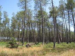
 Maritime pine in the forest of Landes | |
| Country | France |
|---|---|
| State | Landes Gironde |
| Region | Aquitaine |
 | |
Landes de Gascogne Regional Natural Park (French: Parc naturel régional des Landes de Gascogne) is a protected area of pine forest, wetland and oceanic coastline located in the Aquitaine region of southwestern France.
History
The lands comprising the park were largely unpopulated throughout history. The roughly triangular area of the modern-day park was originally an inland sea which had receded, leaving a mostly infertile depression which did not attract human habitation. Largescale public works helped drain, clear, and reforest the area during the nineteenth century but the transformation was limited. By the mid-twentieth century, government attention had turned to protecting the natural environment.[1]
Geography
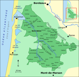
Straddling the departments of Landes and Gironde, Parc naturel régional des Landes de Gascogne comprises the center of the massive forest of Landes. The park extends southeast from Arcachon Bay in Pays de Buch and encompasses the entire Leyre River. The park was originally conceived in 1970 with a total area of 206,000 hectares (510,000 acres),[2] but has been increased to a modern total area of 315,300 hectares.[3]
As of 2011, the park holds 41 small communes with approximately 60,000 inhabitants.[3]
Member communes
The forty-one member communes are: [4]
Major features

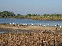
The park maintains a bird sanctuary on Arcachon Bay, the parc ornithologique du Teich.[5] Throughout the year, over 300,000 migratory birds take refuge in its wetlands.[3]
At several sites throughout the park, there are sections of the regional museum, Ḗcomusée de la Grande Lande, which host exhibitions about the history, development and maintenance of the natural lands. The museum also organizes various events focused on Gascon lifestyles and traditions.[1]
The local villages also organize their own events. Thousands of visitors come every year to the Flower Show at Garein, an annual weekend event which celebrated its 25th anniversary in 2010.[6]
Administration

The park is administered by a joint union of local authorities in the Syndicat Mixte du Parc Naturel Régional des Landes de Gascogne, a deliberative assembly of 45 members. The union includes public and private representatives of Gironde, Landes, and Aquitaine. [7]
Park emblem
The park's unique emblem is derived from a woodcut, still visible today, made on the beam of an old building in Luxey. The scene depicts a leaping fox frustrated in its hunt: a solid horizontal line separates him from the hen who strolls serenely in the sun. The situation was a familiar one in the Gascony moors where generations of farmers built their livestock shelters on stilts.[8]
See also
References
- 1 2 Coupe, Alison, ed. (2010). Michelin Green Guide: French Atlantic Coast. London: Michelin Apa Publications. pp. 8; 258–263. ISBN 1-906261-79-2. Retrieved 29 October 2011.
- ↑ IUCN Commission on National Parks and Protected Areas (November 1990). 1990 United Nations list of national parks and protected areas. IUCN. p. 89. ISBN 978-2-8317-0032-8. Retrieved 29 October 2011.
- 1 2 3 "Welcome to the natural regional Park of the Landes de Gascogne". Syndicat Mixte du Parc Naturel Régional des Landes de Gascogne. Retrieved 29 October 2011.
- ↑ Maison du Parc, PNRLG (2011). "41 communes du Parc naturel régional des Landes de Gascogne" (PDF) (in French). Parc Naturel Régional des Landes de Gascogne. Retrieved 29 October 2011.
- ↑ "Teich bird park, official website" (in French). Parc ornithologique du Teich. Retrieved 29 October 2011.
- ↑ Hugon, Jean-Louis (2011). "Curieux de nature" (in French). SudOuest.fr. Retrieved 29 October 2011.
- ↑ "Qui sommes nous?" (in French). Syndicat Mixte du Parc Naturel Régional des Landes de Gascogne. Retrieved 29 October 2011.
- ↑ Fénié, Bénédicte; Fénié, Jean-Jacques (2009). Dictionnaire des Landes (in French). Bordeaux: Éditions Sud Ouest. ISBN 978-2-87901-958-1.
External links
- Official park site (French)
- French Ministry of Agriculture: Report on Landes de Gascogne 1998-1999-2000 and effects of the storm of 27/12/1999
Coordinates: 44°29′23″N 0°47′26″W / 44.48972°N 0.79056°W
