Pennsylvania Route 424
| ||||
|---|---|---|---|---|
|
The Greater Hazleton Chamber Of Commerce Beltway Arthur Gardner Highway | ||||
 | ||||
| Route information | ||||
| Maintained by PennDOT | ||||
| Length: | 3.749 mi[1] (6.033 km) | |||
| Existed: | 2000[2] – present | |||
| Major junctions | ||||
| West end: |
| |||
|
| ||||
| East end: |
| |||
| Location | ||||
| Counties: | Luzerne | |||
| Highway system | ||||
| ||||
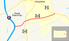
Pennsylvania Route 424 (PA 424) is a 3.75-mile-long (6.04 km) state highway located in north-central Pennsylvania. The western terminus is at Interstate 81 (I-81) exit 141 in Hazle Township. The eastern terminus is at PA 93 on the southeastern edge of Hazleton. The highway is called The Greater Hazleton Chamber Of Commerce Beltway or Arthur Gardner Highway and is a two-lane undivided road that forms a southern bypass of the city of Hazleton in Luzerne County, with an intermediate intersection with PA 309. The section of the road between PA 309 and PA 93 was constructed by 1980 and became State Route 3032 (SR 3032). The road was extended west to I-81 in 1999, and PA 424 was designated between I-81 and PA 93 in 2000. PA 424 was constructed to provide access to the Hazleton Commerce Center and to reduce truck traffic on adjacent roads. There are plans to extend the route west to PA 924 near Humboldt Industrial Park.
Route description
PA 424 begins at I-81 exit 141 in Hazle Township. The route heads east as a two-lane undivided road called The Greater Hazleton Chamber Of Commerce Beltway or Arthur Gardner Highway, passing through forested areas. The road turns northeast and comes to an intersection with PA 309, briefly becoming a divided highway at this point. Past PA 309, PA 424 crosses a Norfolk Southern railroad line and heads into the southern part of Hazleton, continuing east. The route passes through more woodland along with a few industrial establishments, running to the north of a coal mine. The roadway briefly becomes divided again as it crosses Poplar Street. PA 424 continues east and enters Hazle Township again, immediately ending at PA 93.[3][4]
History
The first section of the road to be built was between PA 309 and PA 93, which was constructed by 1980.[5] With the establishment of the Location Referencing System for state roads in 1987, this road was designated as SR 3032.[6][7] The rest of the road between I-81 and PA 309 was built in the late 1990s and opened to traffic in December 1999.[8][9] The entire length of the road between I-81 and PA 93 was designated PA 424 in 2000.[2][8] The highway was built to provide access between I-81 and the Hazleton Commerce Center and to reduce truck traffic on local roads in the Hazleton area. The project cost $10.25 million.[9] This road was one of the four legs of a proposed beltway system to encircle Hazleton.[10] In 2003, PA 424 was renamed from the Hazleton South Beltway to the Greater Hazleton Chamber of Commerce Beltway.[11]
Plans exist for the road to be extended west to PA 924 in the Humboldt Industrial Park. In 2010, the Greater Hazleton Chamber of Commerce pushed for the extension in order to provide economic development to the region.[12] The state provided funding for this extension in the transportation bill in 2013.[13] The extension of PA 424 has not yet entered the design phase.[10]
Major intersections
The entire route is in Luzerne County.
| Location | mi[1] | km | Destinations | Notes | |||
|---|---|---|---|---|---|---|---|
| Hazle Township | 0.000 | 0.000 | Exit 141 (I-81) | ||||
| 1.144 | 1.841 | ||||||
| No major junctions in Hazleton | |||||||
| Hazle Township | 3.749 | 6.033 | |||||
| 1.000 mi = 1.609 km; 1.000 km = 0.621 mi | |||||||
See also
 U.S. Roads portal
 Pennsylvania portal
References
- 1 2 Bureau of Maintenance and Operations (January 2015). Roadway Management System Straight Line Diagrams (Report) (2015 ed.). Pennsylvania Department of Transportation. Retrieved June 30, 2015.
- Luzerne County (PDF)
- 1 2 Monitz, Kelly (February 2, 2000). "Heights Beltway to become state Route 424". Standard-Speaker. Hazleton, PA. p. 17. Retrieved November 20, 2015 – via Newspapers.com.

- ↑ Google (February 21, 2011). "overview of Pennsylvania Route 424" (Map). Google Maps. Google. Retrieved February 21, 2011.
- ↑ Luzerne County, Pennsylvania Highway Map (PDF) (Map). PennDOT. 2011. Retrieved February 20, 2011.
- ↑ General Highway Map Luzerne County Pennsylvania (PDF) (Map). Pennsylvania Department of Transportation. 1980. Retrieved November 19, 2015.
- ↑ "Location Referencing System (LRS) -- Definitions, Uses, and Testing" (PDF). Pennsylvania Department of Transportation. July 19, 2007. Retrieved January 21, 2012.
- ↑ General Highway Map Luzerne County Pennsylvania (PDF) (Map). Pennsylvania Department of Transportation. 1990. Retrieved November 19, 2015.
- 1 2 General Highway Map Luzerne County Pennsylvania (PDF) (Map). Pennsylvania Department of Transportation. 2003. Retrieved November 19, 2015.
- 1 2 "Lackawanna-Luzerne Regional Plan" (PDF). McCormick & Taylor. May 2011. p. 4-15. Retrieved November 18, 2015.
- 1 2 Dino, Jim (April 4, 2015). "Beltway project resumes work". Standard-Speaker. Hazleton, PA. Retrieved November 19, 2015.
- ↑ GREATER HAZLETON CHAMBER OF COMMERCE BELTWAY - DESIGNATION - Act of Dec. 30, 2003, P.L. 453, No. 66 (PDF), General Assembly of Pennsylvania, 2003, retrieved November 19, 2015
- ↑ Dino, Jim (June 25, 2010). "Hazleton Chamber of Commerce pleads for Route 424 extension". Standard-Speaker. Hazleton, PA. Retrieved November 19, 2015.
- ↑ Levy, Marc (November 22, 2013). "Delco bridge repairs, expansion of SEPTA stations on tap". Delaware County Daily Times. Associated Press. Retrieved November 23, 2013.

