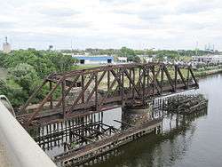
Philadelphia, Wilmington and Baltimore Railroad Bridge No. 1
| Philadelphia, Wilmington and Baltimore Railroad Bridge No. 1 | |
|---|---|
 2011 photo | |
| Coordinates | 39°56′26″N 75°12′18″W / 39.9406°N 75.2050°WCoordinates: 39°56′26″N 75°12′18″W / 39.9406°N 75.2050°W |
| Crosses | Schuylkill River |
| Locale | Philadelphia, Pennsylvania |
| Other name(s) | Grays Ferry Railroad Bridge, PRR South Philadelphia Branch Bridge |
| Characteristics | |
| Design | Through truss swing bridge |
| Material | Steel |
| Longest span | 226.6 feet (69.1 m) |
| History | |
| Engineering design by | American Bridge Company |
| Inaugurated | 1902 |
| Opened | 1902 |
| Closed | 1976 |
| Replaces | Newkirk Viaduct |
Philadelphia, Wilmington and Baltimore Railroad Bridge No. 1 is a swing steel through truss that spans the Schuylkill River between Philadelphia, Pennsylvania's Kingsessing and Grays Ferry neighborhoods. Abandoned in 1976, the bridge is part of a long succession of ferry and bridge crossings that linked Philadelphia to points south. It was built in 1901 for the Philadelphia, Wilmington and Baltimore Railroad by American Bridge Company.[1]
As of August 2016, the bridge's truss is slated to be removed and replaced by a new swing bridge that will become part of the Schuylkill River Trail, a bike trail, with construction tentatively slated to begin in 2017.[2]
Background (to 1901)
The bridge's location has been a major crossing point since the establishment of a ferry here as early as the 17th century and certainly by 1740. In 1777, British troops built a pontoon bridge here during their occupation of Philadelphia, and the newly independent Americans subsequently kept it up, replacing parts as necessary after floods. In 1838, the PW&B built the first permanent bridge here to complete the first direct rail link from Philadelphia to Wilmington, Delaware, and Baltimore, Maryland. Called the Newkirk Viaduct, it was a covered wooden bridge that carried a road as well as one track. The bridge did not initially allow locomotives to pass so the cars were (at least until 1844) pulled by horses over the river and northward along three miles of track to the terminus of the PW&B. A new draw span was constructed in 1891, but maintenance remained difficult for the rest of the decade.[1]
In 1901, when the city of Philadelphia opened an adjacent highway bridge, it absolved the PW&B of the responsibility of carrying the road traffic, and the railroad promptly began building the PW&B Bridge No. 1.
Design and construction (1901-1902)
The bridge has a 226-foot-7-inch (69.1 m) swing span pivoting on a cylindrical stone pier at mid-stream. A wooden pile fender protects the pivot pier and the opened swing span from collisions with boat traffic on the river. The American Bridge Company built the swing span on the fender in its open position, avoiding interference with river traffic.[1] The swing span sits between two 97-foot-9 3⁄8-inch (29.8 m) approach spans.[3]
It was completed and opened in 1902.
Operation and abandonment (1902-1976)
Maximum speed over the bridge was 15 miles per hour (24 km/h).[4]
In 1976, Conrail abandoned the bridge shortly after it acquired the Pennsylvania Railroad properties, and left it permanently open.
Post-abandonment (1977-present)
An unknown party purchased the bridge in 1987.[1] As of 2012, the bridge and the fender pilings continue to exist, deteriorating.
Bike trail proposal
In 2012, Philadelphia Mayor Michael Nutter proposed to return the bridge to service as a part of the Schuylkill River Trail, a bike trail.[5] Under the proposal, the bridge would be raised some 33 feet (10 m) so that boats — in particular, a towboat used to bring oil barges to the Trigen power plant upstream — could pass without swinging it open.[3]
As of 2016, efforts are proceeding to add the bridge to the Schuylkill River Trail. In early May 2016, councilmember Kenyatta Johnson introduced a bill in Philadelphia City Council to allow the city to acquire the bridge and some surrounding land from Conrail.[2]
See also
- List of bridges documented by the Historic American Engineering Record in Pennsylvania
- List of crossings of the Schuylkill River
References
- 1 2 3 4 Spivey, Justin M. (April 2000). "Philadelphia, Wilmington & Baltimore Railroad, Bridge No. 1" (PDF). Historic American Engineering Record. Washington, D.C.: Library of Congress. Retrieved January 29, 2014.
- 1 2 Saksa, Jim (May 5, 2016). "City set to acquire Schuylkill River Swing Bridge from Conrail, clearing path for bike and ped trail river crossing". Plan Philly. Retrieved August 27, 2016.
- 1 2 Amman & Whitney (February 2012). "Grays Ferry Pedestrian Bridge Conceptual Design Report" (PDF). Schuylkill River Development Corporation. p. 174. Retrieved November 23, 2012.
- ↑ "Grays Ferry Moveable Br. (track schematic)". 1969. Retrieved November 24, 2012.
- ↑ Hill, Miriam (November 20, 2012). "Proposed bike trail would cross Schuylkill, access Bartram's Garden". Philadelphia Inquirer.
External links
| Wikimedia Commons has media related to PW&B Railroad Bridge (Philadelphia). |
- Historic American Engineering Record (HAER) No. PA-547, "Philadelphia, Wilmington & Baltimore Railroad, Bridge No. 1"
- "The River As It Was, The River As It Is, The River As It Should Be" By John Frederick Lewis of the City Parks Association, Philadelphia, 1924.
- 1924 photo labeled "The Present State of the East Bank of the Schuylkill at Gray's Ferry Where Our Citizens Met Washington on His Way to His Inauguration."
- 1924 photo labeled "Looking down the River, East Bank, Below Gray's Ferry Where Our Citizens Assembled to Greet Washington."
- 1969 PRR traffic schematic for PW&B No. 1 Bridge
