Quebec Autoroute 31
| ||||
|---|---|---|---|---|
| Autoroute Antonio-Barrette | ||||
 | ||||
| Route information | ||||
| Maintained by Transports Québec | ||||
| Length: | 14.0 km[1][2] (8.7 mi) | |||
| Existed: | 1966[2] – present | |||
| Major junctions | ||||
| South end: |
| |||
| North end: |
| |||
| Location | ||||
| Major cities: | Lavaltrie, Joliette | |||
| Highway system | ||||
| ||||

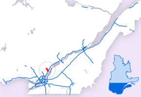
Autoroute 31 (A-31) is an Autoroute in the region of Lanaudière in Quebec. Constructed in 1966, the A-31 primarily links Joliette with the A-40 and in turn to Montreal, Trois-Rivières, and other points served by Quebec's autoroute system. The A-31 is only 14 km (8.7 mi) long, making it one of the shortest autoroutes in the province. It is multiplexed with Route 131 for its entire length.
The A-31 also carries the name Autoroute Antonio-Barrette, named for a politician from Joliette who briefly served as Premier of Quebec in 1960.
Description
The A-31 begins just south of its interchange with A-40 in Lavaltrie. Motorists exiting the A-40 can opt to travel north on A-31 (multiplexed with Route 131) or south on Route 131 to Lavaltrie's city centre. The A-31/A-40 interchange has an unusual configuration, built to accommodate tollbooths (since dismantled). Also unusual for a Quebec autoroute: agricultural vehicles like tractors are permitted to cross over the A-40 by travelling on A-31 from its southern terminus to exit 2. For this reason, an automated traffic regulation system (commissioned in 2009) lowers the speed limit automatically from 100/60 km/h to 90/30 km/h as needed.
Exits at km 2 and km 7 provide access to local roads, while a partial interchange at km 12 serves an industrial zone south of Joliette.
The A-31 ends at km 15 at a cloverleaf interchange with Route 158. Plans for Quebec's autoroute system initially called for A-31 to meet the A-50 at this interchange. Anticipating this outcome, Route 158 in the immediate vicinity of the interchange was constructed as a limited-access highway and signed as A-50. Once plans to extend the A-50 east of the A-15 were abandoned in the 1980s, this stretch of highway was redesignated Route 158. A series of deadly accidents on Route 158 prompted a 2014 petition drive to reconstruct the highway to Autoroute standards and return the designation of A-50.[3]
Motorists exiting the A-31 at km 15 may continue on Route 158 west to St-Esprit, Route 158 east to Berthierville, or Route 131 north to Saint-Félix-de-Valois. Past this interchange, A-31 ends and becomes Boulevard Dollard, which continues into downtown Joliette.
Exit list
| Region | Location | km | mi | Exit | Destinations | Notes | |
|---|---|---|---|---|---|---|---|
| Continues as Route 131 to Lavaltrie | |||||||
| D'Autray | Lavaltrie | 0 | at-grade intersection, South end of Route 131 overlap | ||||
| 1 | |||||||
| 1 | 0.62 | 2 | Rang Saint-Henri, Rang du Point-du-Jour | ||||
| Joliette | Saint-Thomas | 7 | 4.3 | 7 | Saint-Thomas, Saint-Paul | ||
| Joliette | 13 | 8.1 | 14-E | North end of Route 131 overlap | |||
| 14-O | |||||||
| Continues as Boulevard Dollard to Downtown Joliette | |||||||
1.000 mi = 1.609 km; 1.000 km = 0.621 mi
| |||||||
References
- ↑ Ministère des transports, "Distances routières", page (?), Les Publications du Québec, 2005
- 1 2 "Répertoire des autoroutes du Québec" (in French). Transports Québec. Retrieved 2008-02-23.
- ↑ Ferland, Mathieu (24 July 2014). "Une pétition circule pour modifier la route 158". Le Journal de Joliette (in French). Retrieved 18 March 2016.
External links
| Wikimedia Commons has media related to Quebec Autoroute 31. |