Quebec Autoroute 740
| ||||
|---|---|---|---|---|
| Autoroute Robert-Bourassa | ||||
 | ||||
| Route information | ||||
| Maintained by Transports Québec | ||||
| Length: | 7.4 km[1][2] (4.6 mi) | |||
| Existed: | 1975[2] – present | |||
| Major junctions | ||||
| South end: |
 Route 175 / Boulevard Laurier (Université Laval) Route 175 / Boulevard Laurier (Université Laval) | |||
 A-440 A-440 | ||||
| North end: |
 A-40 A-40 | |||
| Location | ||||
| Major cities: | Quebec City | |||
| Highway system | ||||
| ||||


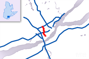
Autoroute 740 is a Quebec Autoroute in metropolitan Quebec City, Canada. A spur route of Autoroute 40, the A-740 runs for 7.3 km (4.5 mi) on a north-south axis (parallel to the St. Lawrence River through the boroughs of Sainte-Foy–Sillery–Cap-Rouge and Les Rivières, with interchanges at the A-440 at exit 4 and the A-40 at exit 9.
Originally named the Autoroute du Vallon for the 17th century road it replaced,[3] in 2006, the Quebec government under then-Premier Jean Charest renamed the highway Autoroute Robert-Bourassa, in honour of a long serving former Quebec Premier.
Route description
The A-740 begins at an intersection with Route 175 (Also called Boulevard Laurier) in suburban Sainte-Foy, tracing the western limits of Université Laval along the northbound lanes and Place Sainte-Foy (a regional shopping mall) along the southbound lanes. Once past the university, the A-740 enters a 300 m tunnel, passing under heavily travelled chemin Sainte-Foy and chemin Quatre-Bourgeois. Passing to the west of Cégep de Sainte-Foy, the A-740 approaches the interchange with the A-440 at exit 4. From here, motorists on the A-440 can travel east (which becomes Boulevard Charest) towards the city centre or west to an interchange with the A-40 and A-73, affording access to Jean Lesage International Airport and points south and west.
Continuing north, the A-440 passes to the west of an industrial park, meets Route 138 at exit 7, then crosses the Saint-Charles River to an interchange with Boulevard Père-Lelièvre at exit 8 on the north shore. The autoroute provides the eastern boundary for a municipal park before meeting the A-40/A-73 (a concurrent route) at a cloverleaf interchange. The A-740 ends shortly after the A-40/A-73 interchange, passing to the west of the Galeries de la Capitale (another regional shopping mall) to an intersection with Boulevard Lebourgneuf.
The original plans called for the A-740 to continue northward after the first section opened in 1982, and so the government preserved the autoroute's intended path. Instead, in 2006, an urban boulevard (Boulevard Robert-Bourassa) was opened on this right of way, running for 4.5 km (2.8 mi) from the northern terminus of the A-740 to Route 369 (Boulevard Bastien).[4] This new route was intended to provide an alternative to the heavily travelled Boulevard St. Jacques (which it parallels).
References
- ↑ Ministère des transports, "Distances routières", page (?), Les Publications du Québec, 2005
- 1 2 "Répertoire des autoroutes du Québec" (in French). Transports Québec. Retrieved 2008-02-23.
- ↑ Ville de Québec. "Fiche de toponyme". http://www.ville.quebec.qc.ca/culture_patrimoine/patrimoine/toponymie/repertoire/fiche.aspx?IdFiche=9401. Retrieved 9 April 2016. External link in
|website=(help) - ↑ Site du premier ministre du Québec. "Le gouvernement du Québec et la Ville de Québec inaugurent le nouveau boulevard Robert-Bourassa". Site du premier ministre du Québec. Retrieved 9 April 2016.
External links
 |
Wikimedia Commons has media related to Quebec Autoroute 740. |