Quebec Route 208
| ||||
|---|---|---|---|---|
 | ||||
| Route information | ||||
| Maintained by Transports Québec | ||||
| Length: | 31.3 km[1] (19.4 mi) | |||
| Major junctions | ||||
| West end: |
| |||
|
| ||||
| East end: |
| |||
| Location | ||||
| Counties: | Memphrémagog | |||
| Highway system | ||||
| ||||

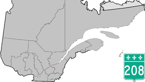
Route 208 is a provincial highway located in the Estrie region of Quebec, which links Ayer's Cliff to Martinville via Hatley and Compton. In each of these latter cities it briefly overlaps with Route 143 and Route 147 respectively.
Municipalities along Route 208
Major intersections
| RCM or ET | Municipality | Km | Junction | Notes |
|---|---|---|---|---|
Western terminus of Route 208 | ||||
| Memphrémagog | Ayer's Cliff | 0.0 | 141 SOUTH: to Stanstead-Est 141 NORTH: to Sainte-Catherine-de-Hatley | |
| Hatley | 4.4 5.0 |
143 SOUTH: to Stanstead-Est 143 NORTH: to Hatley Township | ||
| Compton | 20.9 21.2 |
147 NORTH: to Waterville 147 SOUTH: to Coaticook | ||
| Martinville | 31.3 | 251 SOUTH: to Sainte-Edwidge-de-Clifton 251 NORTH: to Cookshire-Eaton | ||
Eastern terminus of Route 208 | ||||
See also
References
- ↑ Ministère des transports, "Distances routières", page 81, Les Publications du Québec, 2005
External links
- Official Transport Quebec Road Map
- Route 208 on Google Maps
This article is issued from Wikipedia - version of the 11/9/2016. The text is available under the Creative Commons Attribution/Share Alike but additional terms may apply for the media files.