Quebec Route 269
| ||||
|---|---|---|---|---|
 | ||||
| Route information | ||||
| Length: | 138.0 km[1] (85.7 mi) | |||
| Major junctions | ||||
| North end: |
 east of Saint-Agapit east of Saint-Agapit | |||
 in Robertsonville in Robertsonville  in La Guadeloupe in La Guadeloupe  in Saint-Martin in Saint-Martin | ||||
| South end: |
 in Saint-Théophile in Saint-Théophile | |||
| Location | ||||
| Major cities: | Thetford Mines, Adstock | |||
| Highway system | ||||
| ||||


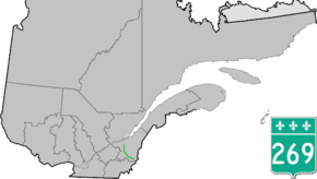
Route 269 is a two-lane north-south highway on the south shore of the Saint Lawrence River, in Quebec, Canada. Its northern terminus is close to Saint-Gilles at the junction of Route 116, and the southern terminus is at the junction of Route 173 in Armstrong, part of Saint-Théophile. The stretch between Saint-Gilles and Kinnear's Mills is very scenic, rising and dipping in the Appalachians.
List of towns along Route 269
- Saint-Gilles
- Saint-Patrice-de-Beaurivage
- Saint-Jacques-de-Leeds
- Kinnear's Mills
- Thetford Mines (Pontbriand)
- Thetford Mines (Robertsonville)
- Adstock (Sacré-Coeur-de-Marie)
- Adstock (Saint-Méthode)
- La Guadeloupe
- Saint-Honoré-de-Shenley
- Saint-Martin
- Saint-Théophile
See also
References
- ↑ Ministère des transports, "Distances routières", page (?), Les Publications du Québec, 2005
External links
- Route 269 on Google Maps
- Provincial Route Map (Courtesy of the Quebec Ministry of Transportation) (French)
This article is issued from Wikipedia - version of the 11/9/2016. The text is available under the Creative Commons Attribution/Share Alike but additional terms may apply for the media files.