Rapid River (Churchill River)
For other places with the same name, see Rapid River.
| Rapid River | |
| River | |
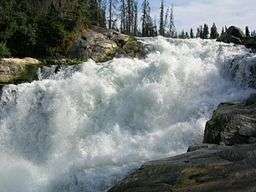 Nistowiak Falls on the Rapid River | |
| Country | Canada |
|---|---|
| Province | Saskatchewan |
| Source | Iskwatikan Lake |
| - elevation | 353 m (1,158 ft) |
| - coordinates | 55°23′34″N 104°21′58″W / 55.39278°N 104.36611°W |
| Mouth | Nistowiak Lake |
| - elevation | 332 m (1,089 ft) |
| - coordinates | 55°24′01″N 104°21′59″W / 55.40028°N 104.36639°WCoordinates: 55°24′01″N 104°21′59″W / 55.40028°N 104.36639°W |
| Length | 1 km (1 mi) |
 Location of the mouth of the Rapid River in Saskatchewan. | |
The Rapid River is a short river in central Saskatchewan, Canada, about 13 kilometres (8 mi) east of the community of Stanley Mission. It is part of the Churchill River drainage basin. The river is about 1,000 metres (3,281 ft) long and flows north from Iskwatikan Lake, which lies downstream from Lac la Ronge, over the Nistowiak Falls, one of the tallest in Saskatchewan, and the Fisher Rapids, to Nistowiak Lake on the Churchill River, which flows to Hudson Bay. The entire river is within Lac La Ronge Provincial Park.
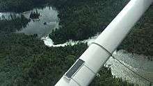
A floatplane flyover of Rapid River in Saskatchewan, Canada including Fisher Rapids and Nistowiak Falls.
Fish species
The fish species in the river include: walleye, sauger, yellow perch, northern pike, lake trout, lake whitefish, cisco, white sucker, shorthead redhorse, longnose sucker, lake sturgeon and burbot.
See also
References
- "Toporama - Topographic Map Sheet73P8". Atlas of Canada. Natural Resources Canada. Retrieved 2010-01-04.
- Fish Species of Saskatchewan
- Lac La Ronge Provincial Park
This article is issued from Wikipedia - version of the 7/4/2016. The text is available under the Creative Commons Attribution/Share Alike but additional terms may apply for the media files.