Richmond County, Nova Scotia
| Richmond County Comté de Richmond (French) Siorramachd Richmond (Gaelic) | ||
|---|---|---|
| County | ||
| ||
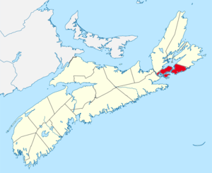
 Location of Richmond County, Nova Scotia | ||
| Coordinates: 45°42′N 60°48′W / 45.7°N 60.8°WCoordinates: 45°42′N 60°48′W / 45.7°N 60.8°W | ||
| Country |
| |
| Province |
| |
| Established | 1835 | |
| Incorporated | April 17, 1879 | |
| Electoral Districts Federal |
Cape Breton—Canso | |
| Provincial | Cape Breton-Richmond | |
| Government | ||
| • Type | Richmond County Municipal Council | |
| • Warden | Steve Sampson | |
| Area[1] | ||
| • Land | 1,244.24 km2 (480.40 sq mi) | |
| Population (2011)[1][2] | ||
| • Total | 9,293 | |
| • Density | 7.5/km2 (19/sq mi) | |
| • Change 2006-11 |
| |
| • Census Rankings - Census divisions Subdivision A Subdivision B Subdivision C - Reserves Chapel Island 5 |
4,072 (795 of 5,008) 1,769 (1,433 of 5,008) 3,455 (904 of 5,008) 444 (3,171 of 5,008) | |
| Time zone | AST (UTC-4) | |
| • Summer (DST) | ADT (UTC-3) | |
| Area code(s) | 902 | |
| Dwellings | 22,951 | |
| Median Income* | $40,188 CDN | |
| Website |
www | |
| ||
Richmond County is a county in the Canadian province of Nova Scotia. For a list of communities in Richmond County, see the eponymous page.
History
Named in honour of Sir Charles Lennox, 4th Duke of Richmond, who was Governor General of British North America 1818-1819, Richmond County was created in 1835.
Richmond County comprises that territory known as the Southern District which was established in 1824 at the time of the dividing of Cape Breton Island into three districts. The boundaries of the Southern District were defined at the time of its establishment. Those same boundaries were determined to be the boundaries of Richmond County by statute in 1847.
The shire town of Richmond Country is Arichat, located on Isle Madame. The community was threatened with closure of its local Court system in June 2015.[3]
Communities
Incorporated communities
Villages
Native reserves'
Census Subdivisions
- Richmond, Subd. A
- Richmond, Subd. B
- Richmond, Subd. C
Access Routes
Highways and numbered routes that run through the county, including external routes that start or finish at the county limits:[4]
|
|
|
Demographics
| Census | Population | Change (%) |
|---|---|---|
| 2011 | 9,293 | |
| 2006 | 9,740 | |
| 2001 | 10,225 | |
| 1996 | 11,022 | |
| 1991 | 11,260 | |
| 1986 | 11,841 | |
| 1981 | 12,824 | N/A |
| 1941 | 10,853 | |
| 1931 | 11,098 | |
| 1921 | 12,464 | |
| 1911 | 13,273 | |
| 1901 | 13,515 | |
| 1891 | 14,399 | |
| 1881 | 15,121 | |
| 1871 | 14,268 | N/A |
| Language | Population | Pct (%) |
|---|---|---|
| English only | 6,620 | 72.19% |
| French only | 2,085 | 22.74% |
| Non-official languages | 285 | 3.11% |
| Multiple responses | 180 | 1.96% |
| Ethnic Origin | Population | Pct (%) |
|---|---|---|
| French | 4,895 | 50.8% |
| Canadian | 3,920 | 40.7% |
| Scottish | 2,310 | 24.0% |
| English | 2,060 | 21.4% |
| Irish | 1,590 | 16.5% |
| Acadian | 710 | 7.4% |
| North American Indian | 685 | 7.1% |
| German | 440 | 4.6% |
See also
- List of municipalities in Nova Scotia
- Central Nova Tourist Association – Tourism Association Representing Colchester County.
References
- 1 2 2006 Statistics Canada Community Profile: Richmond County, Nova Scotia
- ↑ Statistics Canada Population and dwelling counts, for Canada and census subdivisions (municipalities), 2006 and 2001 censuses - 100% data
- ↑ ctvnews.ca: "Old town relics leave Nova Scotia communities feeling empty", 6 Jun 2015
- ↑ Atlantic Canada Back Road Atlas ISBN 978-1-55368-618-7 Pages 56-58, 73
- ↑ Censuses 1871-1941
- ↑ Statistics Canada: 1996, 2001, 2006 census
- ↑ Statistics Canada: 2011 census
- ↑ 2006 Statistics Canada Census Ethnocultural Portrait of Canada: Richmond County, Nova Scotia
External links
| Wikimedia Commons has media related to Richmond County, Nova Scotia. |
 |
Inverness County | Bras d'Or Lake |  | |
| Guysborough County | |
Cape Breton Regional Municipality | ||
| ||||
| | ||||
| Chedabucto Bay | Atlantic Ocean |

