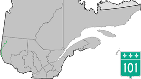
Quebec Route 101
| ||||
|---|---|---|---|---|
 | ||||
| Route information | ||||
| Maintained by Transports Québec | ||||
| Length: | 289.3 km[1] (179.8 mi) | |||
| Major junctions | ||||
| South end: |
| |||
|
| ||||
| North end: |
| |||
| Location | ||||
| Counties: | Témiscamingue / Rouyn-Noranda / Abitibi-Ouest | |||
| Highway system | ||||
| ||||

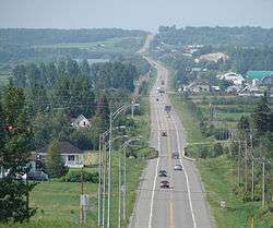
Route 101 near Saint-Bruno-de-Guigues
Route 101 is a highway in northwestern Quebec running in a north to south direction.
In the north the highway begins at Route 111 in Macamic and ends at Témiscaming, a town bordering with Thorne, Ontario on the Ottawa River. It continues as Highway 63 to North Bay, Ontario.
Municipalities along Route 101
- Témiscaming
- Laniel
- Saint-Édouard-de-Fabre
- Ville-Marie
- Duhamel-Ouest
- Saint-Bruno-de-Guigues
- Notre-Dame-du-Nord
- Nédélec
- Rémigny
- Rouyn-Noranda
- Sainte-Germaine-Boulé
- Taschereau
- Poularies
- Macamic
Major intersections
| Region | Location | km | mi | Destinations | Notes |
|---|---|---|---|---|---|
| Témiscamingue | Témiscaming | 0.0 | 0.0 | 63 SOUTH: to North Bay, Ontario | |
| 5.1 | 3.2 | Chemin Kipawa | EAST: to Kipawa and Kebaowek | ||
| Saint-Édouard-de-Fabre | 76.2 | 47.3 | 391 NORTH: to Béarn | ||
| Ville-Marie | 90.2 | 56.0 | 382 EAST: to Lorrainville | ||
| Saint-Bruno-de-Guigues | 104 | 65 | Montée Gauthier | EAST: to Laverlochère | |
| 113 | 70 | Montée Gamache | EAST: to Saint-Eugène-de-Guigues and Angliers | ||
| Notre-Dame-du-Nord | 123.2 | 76.6 | Rue Ontario | WEST: to | |
| Nédélec | 134.4 | 83.5 | Montée Guérin | EAST: to Guérin | |
| Rémigny | 162.5 | 101.0 | 391 SOUTH: to Guérin | ||
| City of Rouyn-Noranda | 192.9 | 119.9 | 391 NORTH: to Rouyn-Noranda | ||
| 204.5 223.5 | 127.1 138.9 | 117 NORTH: to 117 SOUTH: to Val-d'Or | |||
| 238.9 | 148.4 | Chemin Chabot | EAST: to Cléricy and Mont-Brun | ||
| 251.9 | 156.5 | Chemin du Parc | EAST: to Destor | ||
| 257.6 | 160.1 | 393 NORTH: to Duparquet | |||
| Abitibi-Ouest | Sainte-Germaine-Boulé | 265.9 | 165.2 | 1er-et-10e rang | WEST: to Sainte-Germaine-Boulé |
| Poularies | 278.3 | 172.9 | 390 WEST: to Palmarolle 390 EAST: to Taschereau | ||
| Macamic | 289.3 | 179.8 | 111 SOUTH: to Amos 111 NORTH: to La Sarre | ||
1.000 mi = 1.609 km; 1.000 km = 0.621 mi
| |||||
See also
References
- ↑ Ministère des transports, "Distances routières", page 55, Les Publications du Québec, 2005
External links
| Wikimedia Commons has media related to Quebec Route 101. |
- Official Transport Quebec Road Map (Courtesy of the Quebec Ministry of Transportation) (French)
- Route 101 on Google Maps
This article is issued from Wikipedia - version of the 11/9/2016. The text is available under the Creative Commons Attribution/Share Alike but additional terms may apply for the media files.