Connecticut Route 10
| ||||
|---|---|---|---|---|
|
Map of Connecticut with CT 10 highlighted in red | ||||
| Route information | ||||
| Maintained by ConnDOT | ||||
| Length: | 54.28 mi[1] (87.36 km) | |||
| Existed: | 1922 – present | |||
| Major junctions | ||||
| South end: |
| |||
|
| ||||
| North end: |
| |||
| Location | ||||
| Counties: | New Haven, Hartford | |||
| Highway system | ||||
| ||||

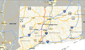
Connecticut Route 10 is a state highway that runs between New Haven and the state line near Granby.
Route description
Route 10 begins at Interstate 95 (I-95) as Ella T. Grasso Boulevard in the city of New Haven. It proceeds northward, crossing US 1 and has a brief concurrency with Route 34. It then turns northwest onto Whalley Avenue, then north onto Fitch Street as Whalley Avenue becomes Route 63. On Fitch Street, it passes by Southern Connecticut State University, then turns east onto Arch Street before entering the town of Hamden. It then turns north onto Dixwell Avenue, and intersects the Wilbur Cross Parkway (Route 15) at Exit 60. In the center of Hamden, it turns onto Whitney Avenue. Proceeding northward, it encounters the northern end of the Route 40 freeway and the western end of Route 22 . In Cheshire, it meets the eastern end of Route 42, and has a brief triplex with Routes 68 and 70. At the north end of town is a junction with I-691 at Exit 3. It then enters Southington, where it has a grade separated intersection with Route 322 and a connection to I-84 east at Exit 29 via SR 597. After passing through the village of Plantsville, it has a junction with the northern end of Route 120 just before downtown, and then becomes Queen Street, a major retail strip. Along Queen Street, it crosses I-84 at Exit 32. At the Plainville town line, it meets the southern end of Route 177. It then meets Route 372, which leads to eastbound access to the Route 72 freeway via Hooker Street (SR 536). After passing under Route 72, Route 10 enters Farmington, then has a grade separated intersection with US 6. Most access to US 6 is provided by Scott Swamp Road (SR 532), except for a direct connection from Route 10 north to US 6 east. In the center of Farmington, it passes by Miss Porter's School before intersecting with Route 4. It then enters Avon, where it turns west along a brief concurrency with US 44. In the center of town, it turns north along with US 202 East, which leaves its concurrency with US 44 and duplexes with Route 10 to Westfield, Massachusetts. In Simsbury, there are juctions with the western end of Route 185, the northern end of Route 167, and the western end of Route 315. In Granby, there is a brief concurrency with Route 189, and a junction with Route 20. About 3.5 miles later, Routes 10 and 202 cross the Massachusetts state line into the town of Southwick.
The Southington section of Route 10 was dedicated on Aug. 6, 1960 (and rededicated on Oct. 6, 2007) as the Louis G. Tolles Memorial Highway in honor of the late Southington native and leader of the Connecticut State Grange (1885–1956).
History
Route 10 originally followed a different route south of Granby, Connecticut, starting in the town of Old Saybrook[2] instead of at its current New Haven terminus. It moved to its current alignment along the Connecticut section of the College Highway in 1932, with the former alignment becoming the original Route 9. The original routing is now Routes 154, 99, and 189. During the 1960s Connecticut planned on building an expressway along the Route 10 corridor, but the only part of this plan actually constructed was Route 40 in the Mount Carmel area of Hamden, as well as several exit ramps connecting Route 10 to I-84 southwest of Hartford.
-
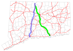
Map of Connecticut showing the original 1920s route in green and the modern route in blue -
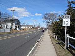
Northbound in Cheshire
Junction list
| County | Location | mi | km | Destinations | Notes |
|---|---|---|---|---|---|
| New Haven | New Haven | 0.00 | 0.00 | I-95 Exit 44 | |
| 1.29 | 2.08 | ||||
| 1.87 | 3.01 | Eastern end of CT 34 overlap | |||
| 2.20 | 3.54 | Western end of CT 34 overlap | |||
| 3.42 | 5.50 | ||||
| Hamden | 7.03 | 11.31 | Route 15 Exit 60 | ||
| 10.05 | 16.17 | To I-91 Exit 10 | |||
| 10.27 | 16.53 | ||||
| Cheshire | 15.77 | 25.38 | |||
| 16.94 | 27.26 | South end of CT 68/70 overlap | |||
| 17.09 | 27.50 | North end of CT 68/70 overlap | |||
| 20.99 | 33.78 | I-691 Exit 3 | |||
| Hartford | Southington | 21.55 | 34.68 | Grade separated | |
| 22.25 | 35.81 | SR 597; I-84 west Exit 29 | |||
| 23.25 | 37.42 | West Main St. | To I-84 Exit 30 | ||
| 24.28 | 39.07 | ||||
| 26.75 | 43.05 | I-84 Exit 32 | |||
| Plainville | 28.09 | 45.21 | |||
| 29.82 | 47.99 | ||||
| Farmington | 32.35 | 52.06 | One-way northbound/eastbound connector. Other connections use SR 552 | ||
| 33.85 | 54.48 | ||||
| Avon | 39.42 | 63.44 | Eastern terminus of US 44 overlap | ||
| 40.16 | 64.63 | Western terminus of US 44 overlap. Western terminus of US 202 overlap | |||
| Simsbury | 42.99 | 69.19 | |||
| 44.75 | 72.02 | ||||
| 46.81 | 75.33 | ||||
| Granby | 50.84 | 81.82 | Southern terminus of CT 189 overlap; Old Route 10 continues south on Route 189 | ||
| 50.92 | 81.95 | Northern terminus of CT 189 overlap | |||
| 54.28 | 87.36 | State line | |||
| 1.000 mi = 1.609 km; 1.000 km = 0.621 mi | |||||
See also
References
- ↑ Connecticut State Numbered Routes and Roads as of December 31, 2004 Archived 2015-07-26 at WebCite (PDF)
- ↑ Oglesby, Scott (2004-09-04). "Connecticut New England Interstates: NE 10". Connecticut Roads. kurumi.com. Retrieved 2006-07-10.
External links
![]() Media related to Connecticut Route 10 at Wikimedia Commons
Media related to Connecticut Route 10 at Wikimedia Commons
