Tennessee State Route 20
| ||||
|---|---|---|---|---|
 | ||||
| Route information | ||||
| Maintained by TDOT | ||||
| Length: | 143.04 mi[1][2] (230.20 km) | |||
| Existed: | 1917 – present | |||
| Major junctions | ||||
| West end: |
| |||
|
| ||||
| East end: |
| |||
| Location | ||||
| Counties: | Dyer, Crockett, Madison, Henderson, Decatur, Perry, Lewis, Lawrence, Maury | |||
| Highway system | ||||
| ||||
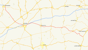
State Route 20 (abbreviated SR 20) is a 143.04-mile (230.20 km) long west–east primary state route beginning in Dyersburg and ending near Summertown. SR 20 is unsigned and overlapped with US 412, except a short section between Hohenwald and Summertown.
Route description
SR 20 begins in Dyersburg at an expansive parclo interchange at the route's junction with US 51, SR 211, and hidden SR 3. SR 20 begins as a four-lane expressway with partial access control and continues east traversing mostly farmland through rural Dyer, Crockett, and Madison counties. At Jackson, Tennessee, SR 20 remains hidden and follows US 412 Business through the city while US 412 is overlapped with Interstate 40 between Exit 79 and Exit 87. SR 20 follows Hollywood Drive and North Parkway through the city of Jackson and is briefly overlapped with US 70 in east Jackson. The route is a two-lane highway on Hollywood Drive and US 70 and is a mix of four-lane divided or five-lane undivided on North Parkway inside Jackson. Beyond Jackson, SR 20 resumes its hidden overlap with US 412 and continues east toward Lexington as a two-lane highway. Construction is in progress to expand this route to a four-lane highway on a section between the Madison County Line and Crucifer. SR 20 between Chesterfield and Summertown is largely a narrow two-lane rural route carrying a 55 mph (89 km/h) speed limit. State Route 20 is designated as part of the Delta Development Highway System[3] throughout West Tennessee and carries a Tennessee Scenic Parkway designation from Lexington to Linden and again from Hohenwald to Summertown.[4]
History
Prior to 1981[5] and dating back as far as 1958,[6] SR 20 at its western end extended beyond Dyersburg following what is now SR 210, US 51, SR 211 and SR 104 to Heloise, Tennessee on the Mississippi River in extreme western Dyer County.[5]
Future
Tennessee Department of Transportation currently has plans to expand existing SR 20 from two-lane to four-lane or completely reconstruct the route on a new alignment from Interstate 40 in Madison County to the Tennessee River near Perryville.[3] Construction is scheduled to begin in 2008 to widen a portion of SR 20 to four-lanes from the Madison County line to Crucifer Road.[7]
Major intersections
| County | Location | mi[8] | km | Destinations | Notes |
|---|---|---|---|---|---|
| Dyer | Dyersburg | 0.00 | 0.00 | Western terminus of SR 20. Hidden SR 20 begins overlapped with US 412 | |
| 3.01 | 4.84 | ||||
| Bonicord | 7.40 | 11.91 | |||
| Crockett | Friendship | 15.55 | 25.03 | ||
| Cairo | 19.50 | 31.38 | |||
| 21.11 | 33.97 | ||||
| Alamo | 23.39 | 37.64 | |||
| Bells | 27.54 | 44.32 | |||
| 29.83 | 48.01 | ||||
| 30.82 | 49.60 | ||||
| Madison | Jackson | 41.85 | 67.35 | Hidden SR 20 continues east through Jackson overlapped with US 412 Business. | |
| 43.65 | 70.25 | ||||
| 44.98 | 72.39 | ||||
| 48.08 | 77.38 | SR 20/US 412 BUS begins brief overlap with US 70/SR 1 | |||
| 50.86 | 81.85 | Overlap with US 70/SR 1 ends. US 412 Business Ends. Hidden SR 20 resumes overlap with US 412 | |||
| Springbrook | 57.50 | 92.54 | |||
| Henderson | Lexington | 70.15 | 112.90 | Overlap with SR 104 begins. | |
| 71.84 | 115.62 | ||||
| 72.03 | 115.92 | To Natchez Trace State Park. Overlap with SR 104 ends and overlap with SR 114 begins. | |||
| Chesterfield | 79.40 | 127.78 | Overlap with SR 114 ends. | ||
| Decatur | Beacon | 84.38 | 135.80 | ||
| Parsons | 87.55 | 140.90 | |||
| Perryville | 91.88 | 147.87 | Overlap with SR 100 begins. | ||
| Perry | Cypress Creek | 93.94 | 151.18 | Overlap with SR 100 continues. | |
| Linden | 105.44 | 169.69 | Overlap with SR 100 continues. | ||
| Chestnut Grove | 108.23 | 174.18 | Overlap with SR 100 ends. | ||
| Lewis | Hohenwald | 123.88 | 199.37 | SR 20/US 412 overlap ends. Brief overlap with SR 48 & SR 99 begins. | |
| 124.30 | 200.04 | Overlap with SR 48 ends. SR 20/SR 99 overlap continues. | |||
| 124.58 | 200.49 | Overlap with SR 99 ends. SR 20 becomes a fully signed route. | |||
| Gordonsburg | 130.74 | 210.41 | |||
| Lawrence | Summertown | 141.02 | 226.95 | Overlap with SR 240 Begins. | |
| 142.08 | 228.66 | Overlap with SR 240 ends. | |||
| Maury | 143.04 | 230.20 | Eastern terminus of SR 20. | ||
1.000 mi = 1.609 km; 1.000 km = 0.621 mi
| |||||
See also
External links
References
- ↑ TDOT Region 3 Pavement Condition Data
- ↑ TDOT Region 4 Pavement Condition Data
- 1 2 Delta Regional Authority, State of Tennessee
- ↑ Tennessee Department of Transportation County Maps and City Maps
- 1 2 1981 Tennessee Official Transportation Map. Nashville, Tennessee: Tennessee Department of Transportation. 1981–1982.
- ↑ History of the Tennessee Highway Deparmement. Nashville, Tennessee: Tennessee State Highway Department, Highway Survey Planning Division. 1959. Page 54.
- ↑ 2008-2010 Transportation Improvement Program
- ↑ retrieved from Delorme Street Atlas USA
