Samaria, Idaho
| Samaria, Idaho | |
|---|---|
| Unincorporated community | |
 Samaria, Idaho  Samaria, Idaho | |
| Coordinates: 42°07′04″N 112°20′13″W / 42.11778°N 112.33694°WCoordinates: 42°07′04″N 112°20′13″W / 42.11778°N 112.33694°W | |
| Country | United States |
| State | Idaho |
| County | Oneida |
| Elevation | 4,478 ft (1,365 m) |
| Time zone | Mountain (MST) (UTC-7) |
| • Summer (DST) | MDT (UTC-6) |
| Area code(s) | 208 |
| GNIS feature ID | 398088[1] |
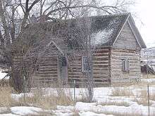
Log cabin in Samaria
Samaria is an unincorporated community in Oneida County, Idaho, United States. Samaria is 7 miles (11 km) southwest of Malad City. The Samaria Historic District is listed on the National Register of Historic Places.
References
Municipalities and communities of Oneida County, Idaho, United States | ||
|---|---|---|
| City | ||
| Unincorporated communities |
| |
This article is issued from Wikipedia - version of the 8/8/2016. The text is available under the Creative Commons Attribution/Share Alike but additional terms may apply for the media files.