Santuk District
| Santuk ស្រុកសន្ទុក | |
|---|---|
| District (srok) | |
  Santuk Location in Cambodia | |
| Coordinates: 12°40′N 105°30′E / 12.667°N 105.500°E | |
| Country |
 Cambodia Cambodia |
| Province | Kampong Thom |
| Time zone | +7 |
| Geocode | 0607 |
Santuk is a district within Kampong Thom Province, in central Cambodia. According to the 1998 census of Cambodia, it had a population of 58,434.[1] Santuk Silk Farm and Phnom Santuk lie in the district.
References
- ↑ "General Population Census of Cambodia 1998, Final Census Results" (PDF). National Institute of Statistics, Ministry of Planning, Cambodia. August 2002. Retrieved 2010-11-24. See page 110.
| Capital city | 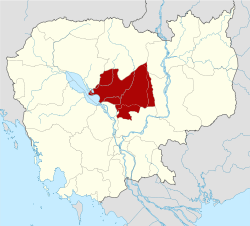 | |
|---|---|---|
| Districts | ||
Coordinates: 12°40′N 105°30′E / 12.667°N 105.500°E
This article is issued from Wikipedia - version of the 2/2/2014. The text is available under the Creative Commons Attribution/Share Alike but additional terms may apply for the media files.